


The summit of New Hampshire’s tenth-tallest peak, 360-degree views, and 5+ mile ski descent make skiing Mount Moosilauke’s Carriage Road a must-do trip for New England backcountry enthusiasts.
The Carriage Road on Mount Moosilauke is one of New England’s classic backcountry ski trips. It offers a gentle ascent to the summit of New Hampshire’s tenth-tallest mountain (and one of its most popular peaks) while tackling moderately challenging skiing as it descends roughly 3,000 feet in over five miles.
Quick Facts
Distance: 10.2 miles round-trip
Time to Complete: 1 day
Difficulty: ★★★★
Scenery: ★★★★★
Turn-By-Turn
A ski up and down the Carriage Road begins and ends on Breezy Point Road, located off Route 118 in Warren, New Hampshire. The Carriage Road starts pretty much where Breezy Point Road ends, although in some winters the plow doesn’t quite make it to the end of the road. In any case, there’s typically a prominent place for parking near the end of the road. Park here, being sure to leave room for fellow skiers and riders.
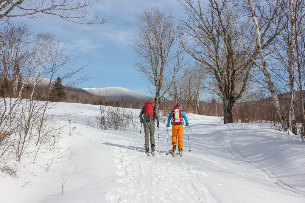
Starting Out
Get started by skinning straight up the road as it traverses an open field. There you’ll find the sign for the start of the Carriage Road proper. From the sign, the trail ascends roughly 3,000 feet over 5.1 miles to the summit of Mount Moosilauke.
The incline on the Carriage Road’s opening section is quite gradual. In good snow conditions (think stellar coverage leaving the car), this section is smooth sailing. In lower snow years or spring-like conditions, there are some water bars and small dips in this section that can slow things down. If that’s the case, use the time to scout a descent line, as you’ll want to do what you can to keep your momentum up on this flattish portion of the ski out.
Crossing the Bridge
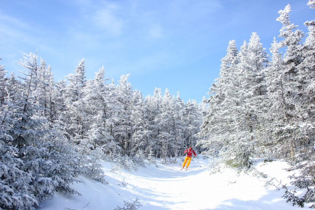
The Carriage Road changes in character after crossing a bridge over Big Brook. From here, the trail begins to climb more steadily and the appeal of skiing the Carriage Road starts to become apparent. Keep an eye on the surrounding open forest and try to remember the location of the potential glades you can sample on the descent.
As the Carriage Road gains elevation, the Hurricane Trail—which joins the Carriage Road on the hikers’ left just before the bridge—departs on hikers’ right.
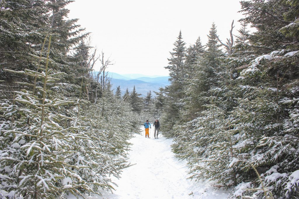
The Lower Switchbacks
Above the junction with the Hurricane Trail, the Carriage Road begins a series of long, loping switchbacks. In good snow conditions, this is one of the highlights of the descent, with tight turns transitioning into long runouts. Because the switchbacks have a combined 800-foot vertical drop, this is also the most strenuous part of the ascent so far.
As you climb, the switchbacks get tighter and tighter, with progressively less runout between them. Soon you’ll encounter the Snapper Trail entering on hikers’ right. At the three-mile mark of the ascent, there is a small clearing that offers a nice place to take a break and have a snack if you haven’t already.
The Upper Switchbacks
Above the Snapper Trail, the Carriage Road enters a second set of switchbacks, becoming a little tighter, slightly steeper, and more exposed to the elements. The trail continues this way for a little over a mile, where it enters a narrow section just below the split for Moosilauke’s shorter and less-traveled south summit, the aptly named South Peak.
The junction of the Carriage Road, the Glencliff Trail, and the herd path for South Peak is a nice open space. Since it is one of the last locations on the ascent that is fully protected from the elements, this is an excellent place to have a snack and bundle up for the remaining above-treeline push. If it’s getting late in the day, the conditions above treeline are unappealing, or you’re just anxious to start skiing, this is a logical turnaround point, as the best skiing is typically found below this point.
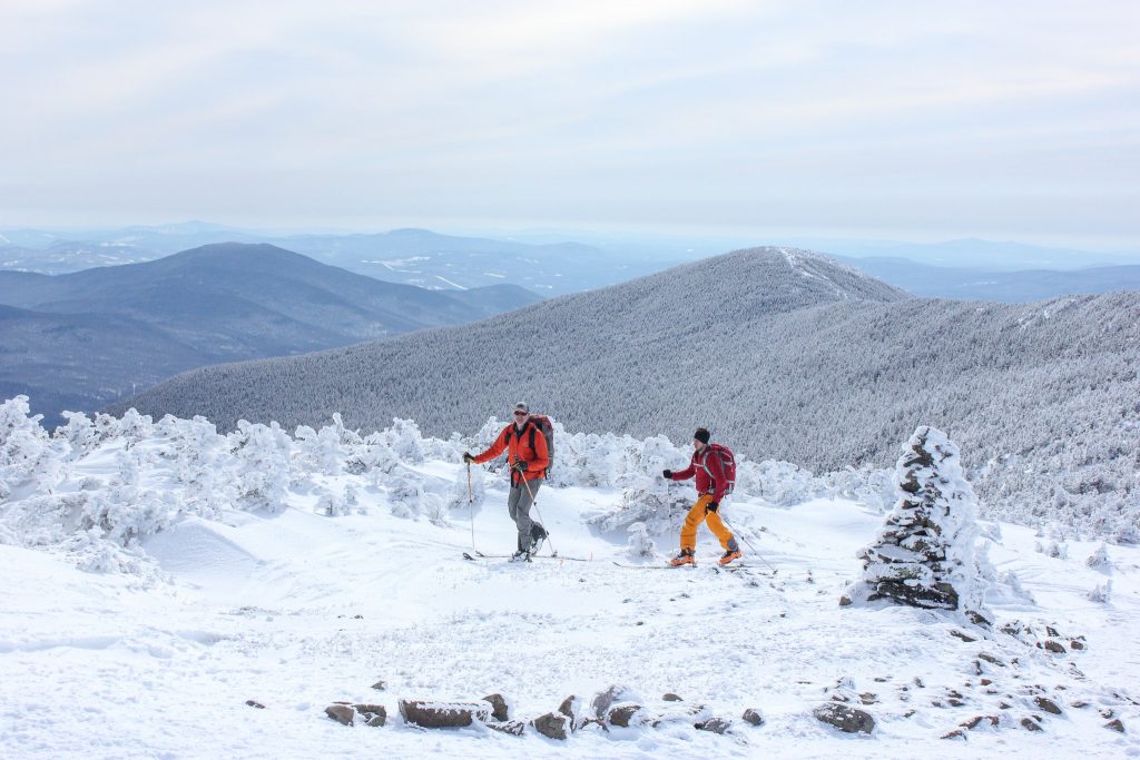
The Ridge Traverse
Leaving the sheltered junction, those continuing toward the summit will cross the narrow track along the ridge between South Peak and Moosilauke’s summit cone. Depending on snow depth, the short trees on the ridge sometimes offer protection from the prevailing west wind. But often, the snow is pretty deep—enough to cover much of the scrubby trees along the ridge.
Mostly flat, the ridge traverse has a few small bumps that sometimes make for some precarious skinning. When the trees thin out, you’ll know you are close to the final ascent of Moosilauke’s summit cone. As you leave the last of this coverage, be prepared—on windy days, the last push to the summit can be quite blustery.
The Final Push
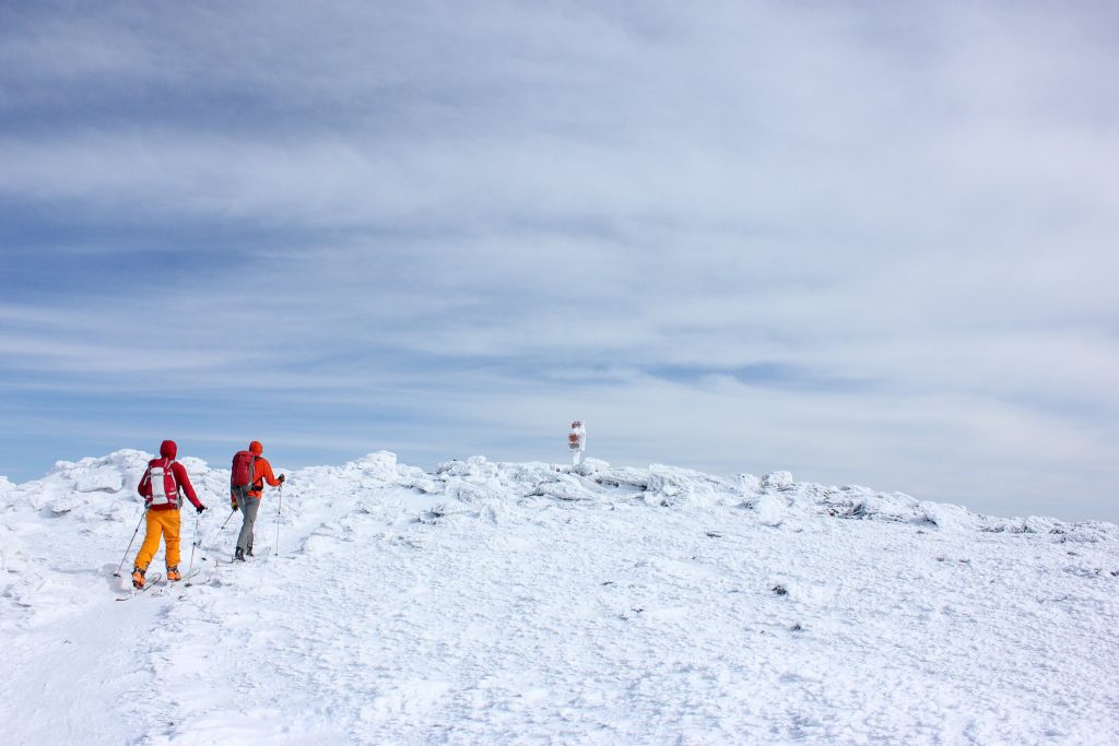
The ascent up Moosilauke’s summit cone is quite condition-dependent. In the best conditions, it is a smooth skin up the well-marked path to the summit. In the worst conditions, the cone is windblown and icy. In the latter situation, if you have traction devices, it is often faster to drop your skis and hike to the summit.
No matter the trail conditions, it is almost always windy on the summit cone. Anticipate the wind pushing you around. On days when the wind is strong, have goggles and full face protection ready.
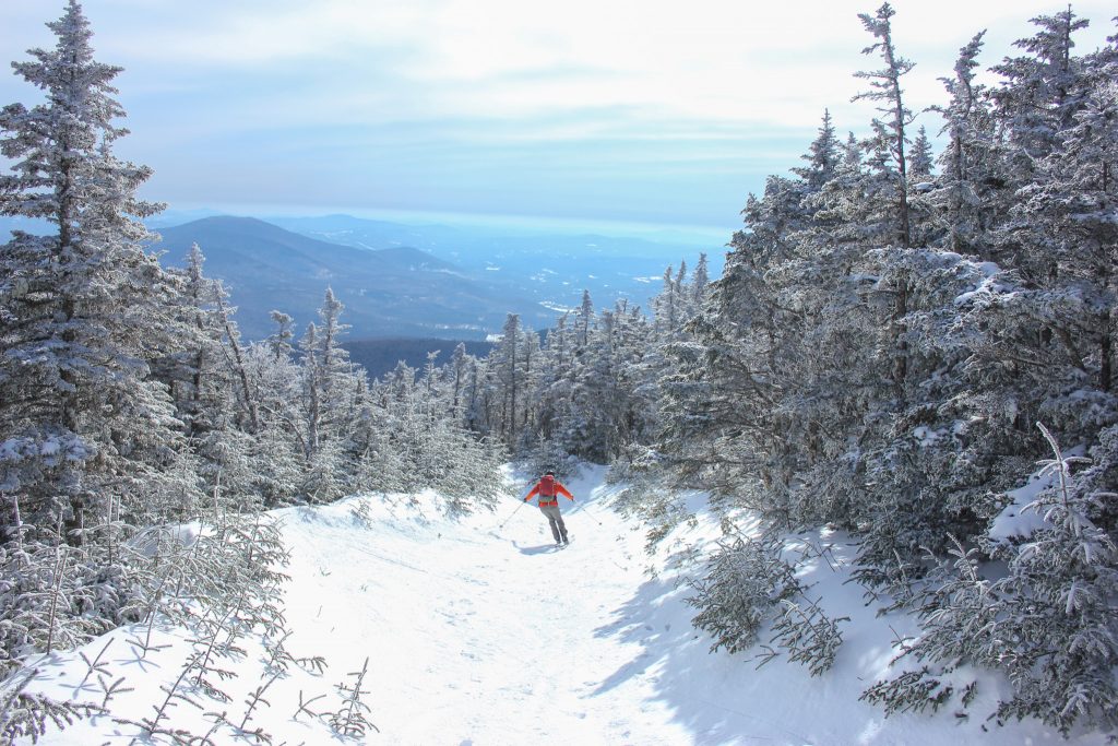
The summit proper offers a few windbreaks near the very popular summit sign. In particular, the windbreak just east of the sign offers a somewhat sheltered spot to take in the wonderful 360-degree views atop Moosilauke. Enjoy the views of Vermont’s Green Mountains to the west and the White Mountains to the north, east, and south. On clear days, Franconia Ridge is often prominent to the northeast.
Down You Go
If the idea of skinning up one of the Northeast’s iconic peaks isn’t enough to tempt you, then thinking about the 5+ miles of uninterrupted skiing on the Carriage Road might. If conditions allow, you can retrace your tracks from the summit to your car in the Breezy Point Road parking lot without ever taking off your skis. The best skiing extends from just below South Peak to the bridge crossing Big Brook.
Although the Carriage Road wasn’t built with downhill skiing in mind, it’s easy to convince backcountry skiers otherwise. Because it was originally constructed to lead horses to the mountain’s summit, the grade is consistent but never exceedingly steep. This is perfect for those looking to link turns and take in the mountain’s incredible views. Most of the trail is reasonably wide (except for a short section just below South Peak) and most of the turns are followed by long runouts. This gives less-experienced backcountry skiers ample room for making turns and dumping speed.
One thing that you’re unlikely to find on a trip up the Carriage Road is stellar skiing on the “summit snowfields.” Although many blogs and guidebooks allude to superb skiing on the summit cone, even on the best days, the summit is usually so wind-blown that there’s barely enough snow to allow for some defensive skiing back to the ridgeline. On the worst days, the upper mountain has been swept of almost all of its snow, necessitating the use of MICROspikes or crampons to descend from the summit proper.
The Kit for Skiing Moosilauke’s Carriage Road
- A warm down or synthetic parka like the EMS Featherpack (men’s/women’s) is great for staying warm during rest breaks, the chilly ridge traverse, the transition from uphill to downhill, and emergencies. On super-cold days, you can even wear it for the ski back to the Breezy Point Road parking lot.
- Because it gets dark quickly in the winter and skiing is treacherous in the dark, add a headlamp like the powerful and rechargeable Black Diamond Spot 400 to your pack.
- Whether it’s the strong glare of the sun reflecting off the snow on a bluebird day or a biting wind on the summit cone, sunglasses and goggles are key pieces of gear for any ski trip on Moosilauke.
- Skiing the Carriage Road is a big day, so be sure to bring enough calories to keep you going. Food that doesn’t freeze—like Nature Valley bars, trail mix, and leftover pizza—are excellent winter food choices to keep you going.
Have more questions about what gear to bring? Check out How to Pack Your Bag for Backcountry Skiing for the skinny on everything from layers to accessories to first aid.
Keys to Skiing Moosilauke’s Carriage Road
- Start cold so you won’t have to stop after 10 minutes to lose a layer. More importantly, if you’re not over-layered, you’re less likely to sweat through your layers, keeping you warmer in the long run.
- Just because Mount Moosilauke is a relatively southern peak compared to other popular New Hampshire backcountry spots, don’t be fooled into thinking it’s an easy trip. At just over 4,800 feet tall, it is the state’s tenth-tallest mountain and it stands alone, unprotected from the prevailing west wind. Be ready to experience full winter conditions on the ridge traverse and summit cone.
- Know when to say when. If you start the ridge traverse and decide that it’s too windy, too cold, or you just have a bad feeling, don’t hesitate to turn around. Moosilauke’s South Summit is a fantastic consolation prize.
- Celebrate a wonderful day on the trail at the Woodstock Inn Brewery in nearby Woodstock. Their Nasty Nachos are top-notch, while their burgers are a fantastic way to re-energize after the ascent. Wash it all down with a 4000-footer IPA.
Looking for more backcountry skiing options in the Granite State? Check out goEast’s Alpha Guide to Skiing in Tuckerman Ravine as well as these sweet backcountry glades.
Related Posts


[…] Skin and ski Mt. Moosilauke. […]
[…] for more information on skiing Mount Moosilauke? Check out my goEast article about […]
[…] these Northeast classics: Shoestring Gully, the Lion Head Winter Route, the Cog on Mt. Washington, Mt. Moosilauke’s Carriage Road, or Mt. Cardigan’s Duke and Alexandria ski […]