

Editor’s note: The alpine along the Presidential Range is extremely fragile and off-trail travel can do irreparable harm to the delicate plant life. For that reason, goEast does not recommend hikers venture off-trail along the Crawford Path and specific details about the exact location of the former trail have been removed from this article. The authors took specific steps to ensure they made no impact on the environment.
From the comfort of our home computers, it didn’t seem that daunting. Finding the remnants of a 100-year-old abandoned shelter along the original route of the Crawford Path, somewhere between Mount Monroe and the summit of Mount Washington couldn’t be that hard. After all, traces of the original route are discernible on Google Earth. We just needed to hike to the general vicinity, find the trail, and then follow it along until we (hopefully) stumble upon the shelter. Easy! But having spent our adult lives hiking in the region, we should have known that the White Mountains wouldn’t give up their secrets so easily.
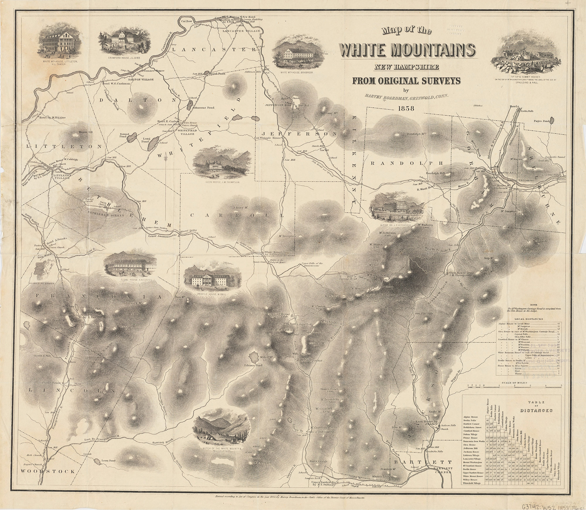
Winding its way across the southern Presidentials toward Mount Washington’s summit, the Crawford Path has captured the hearts of hikers for centuries. Built by Abel and Ethan Crawford in 1819, the trail marked the birthplace of wilderness activity in the White Mountains. It’s opening, as Christopher Johnson writes in This Grand & Magnificent Place: The Wilderness Heritage of the White Mountains, coincided with a burgeoning outdoor movement, where “Americans were beginning to view the mountain wilderness as worthy of exploration for personal, aesthetic, and scientific reasons.”
While an increasing number of visitors used the trail in those early years, often guided by Ethan Crawford or, later, one of his employees, they’d be shocked by how many hikers have followed in their footsteps now. So far today, we’ve already encountered hundreds of people. And we’ve barely even left the parking lot.
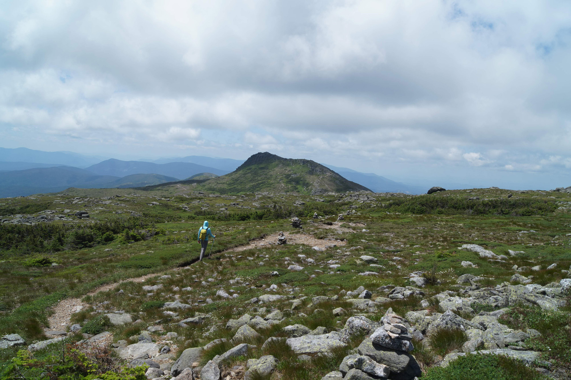
The vast majority of the nation’s oldest continuously maintained hiking trail still follows the original route. It leaves Crawford Depot at the top of Crawford Notch, then climbs gradually up Mount Pierce. Just below Pierce’s summit, the trail turns north, a streak of well-trodden dirt amongst a sea of alpine green as it traverses near the west rim of Oakes Gulf, past Mount Eisenhower and Mount Monroe. Around the seven-mile mark, the trail begins its final ascent, climbing a little over a mile up Mount Washington’s rocky summit cone. The one exception is the section between Mount Monroe and the Westside Trail on Mount Washington—that section of trail was relocated from the long, open ridge and tucked in next to Lakes of the Clouds before climbing up the less-windy underside of the ridge. It’s the original path we’re heading for today.
Several hours into our hike, we’re standing on Mount Monroe’s summit, our eyes tracing the Crawford Path below us, first as it traverses north along the western rim of Oakes Gulf, then as it descends down toward the relative shelter of the Lakes of the Clouds. Once we spy the Lakes of the Clouds Hut, we visually backtrack, working back up the Crawford Path until it reaches a flat area near the rim of Oakes Gulf. Now oriented, we begin scanning the area to the northeast, where our intuition suggests we’ll see the remnants of the old trail.
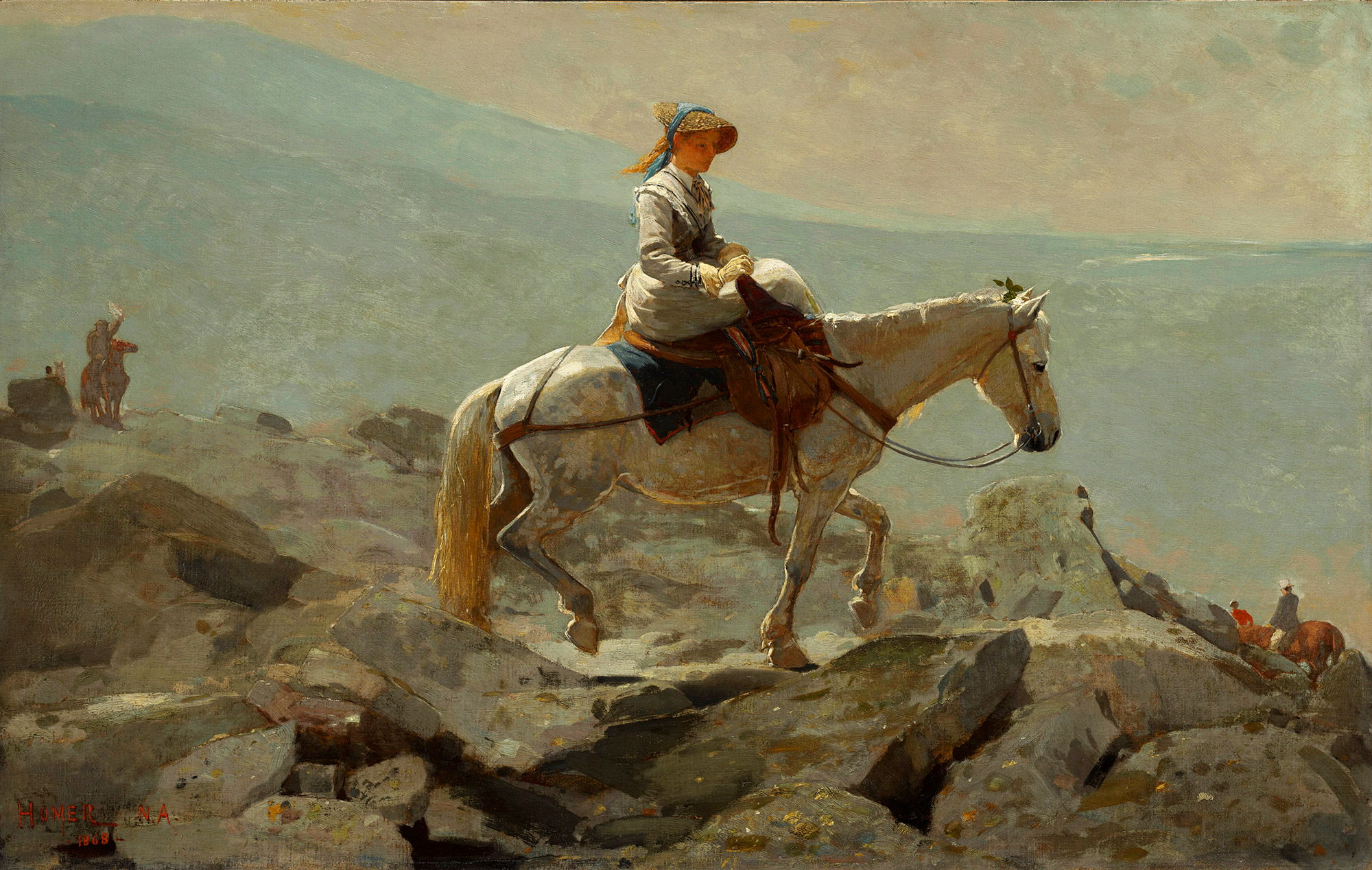
One thing we’re looking for is terrain capable of being climbed by a horse. Although the trail’s origins are as a footpath used by Abel and Ethan Crawford to guide tourists to the summit of Mount Washington, in 1840 it was converted to a bridle path by Abel’s grandson (Ethan’s son), Thomas. Shortly thereafter, Abel made the first ascent of Mount Washington by horseback at the age of 74.
Interest in the area continued to grow during the 1850s and 1860s, and the summit of Mount Washington was a happening place, with five bridle paths to the summit along with a carriage road and the Cog Railway (which, coincidentally, happens to be celebrating its 150th anniversary this year). Two hotels also dotted the summit. And although the era of bridle paths was short lived due to a decline in mountain tourism in the immediate aftermath of the Civil War, how the public accesses Mount Washington and its surroundings remains a recurrent theme.
From Mount Monroe, we’d spotted a greenish path winding through the rocks and rubble heading up a gradual incline running across the Camel Trail toward the intersection of the Tuckerman Crossover and the Davis Path. Generally consistent with our Google Earth imagery, it seems like the perfect route for a horse to take up Mount Washington (even though the Crawford Path had largely reverted to a footpath by the 1870s). Thus, our plan is to hike from the hut to the Tuckerman Crossover, then follow that to its intersection with the Davis Path.
As we traverse this web of trails, it is clear that the Appalachian Mountain Club (AMC) and other trail crews have been busy—large, well-maintained cairns mark the current Crawford and Davis Paths. Much of this trail building energy dates to 1876, which Guy and Laura Waterman, the preeminent historians of hiking and climbing in the Northeast, describe in Forest and Cragas “a pivotal year” for hiking in the White Mountains. That year, the AMC was founded, the first hiker-focused guide book was published (A Guide to the White Mountainsby M.F. Sweetser), and the “first sustained period of trail building began in the White Mountains.” Essentially, the trails, as we know them today anyway, date to that period.
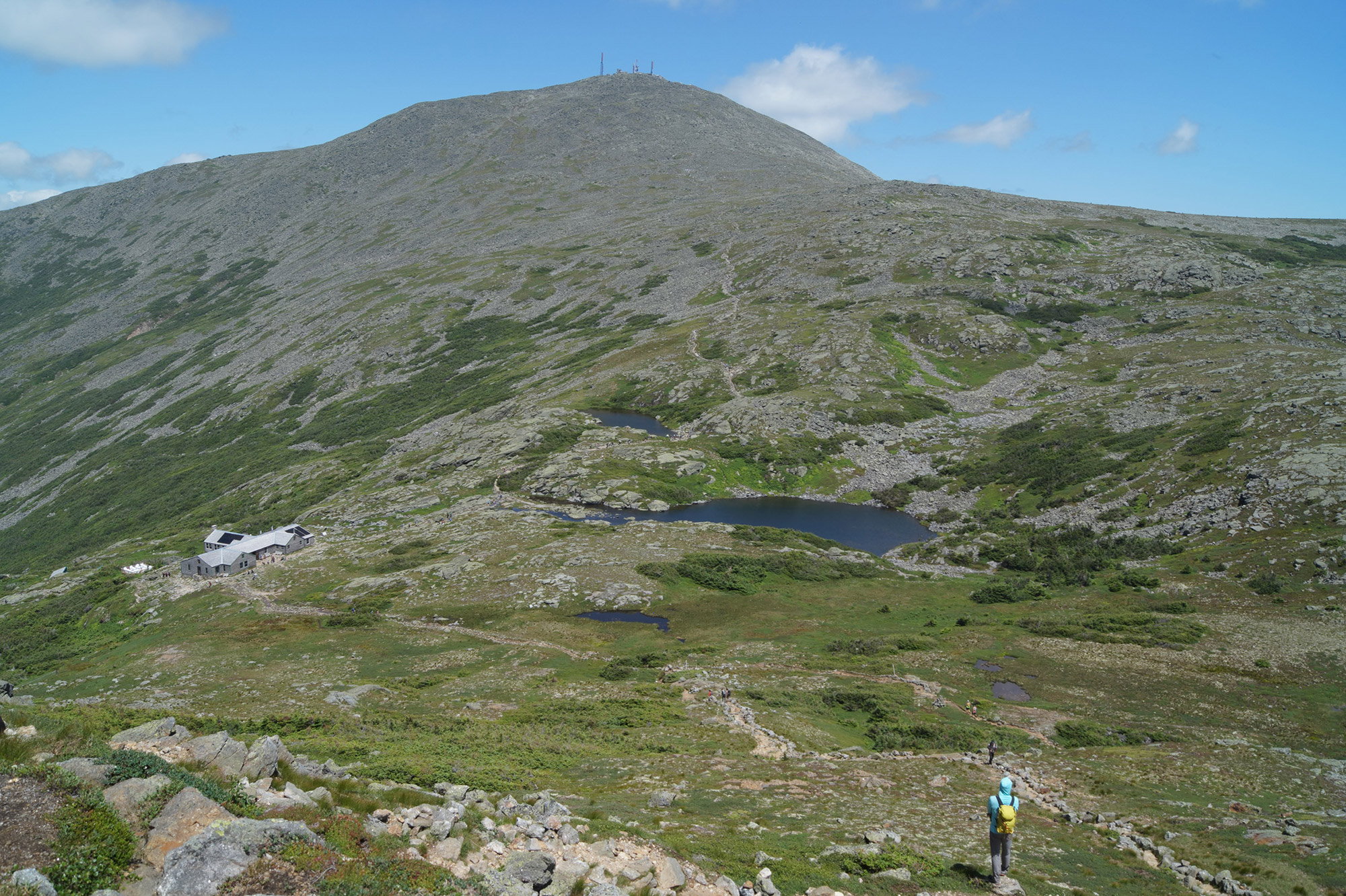
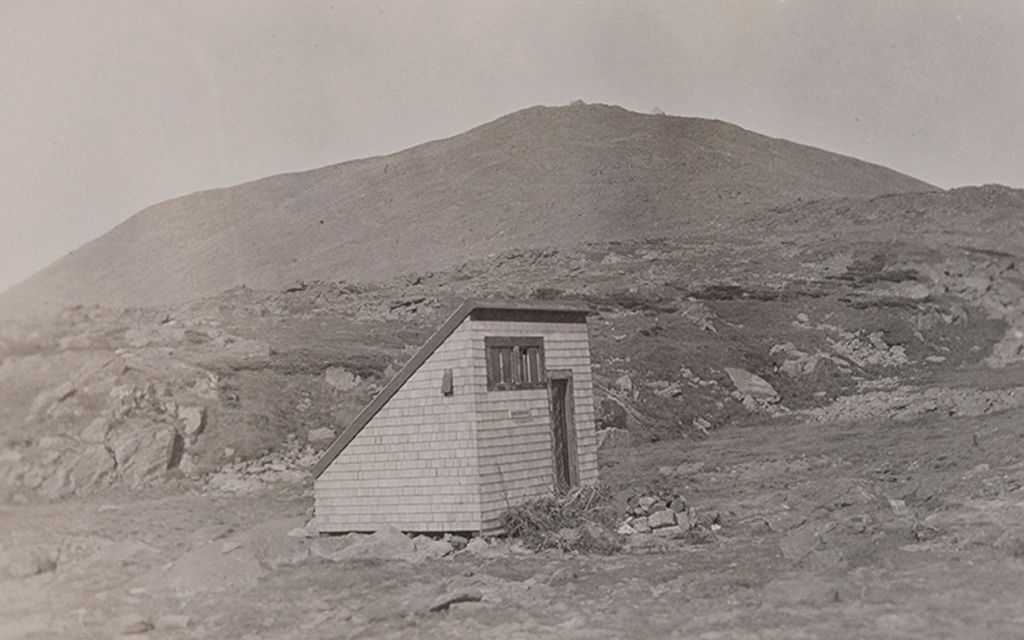
Crossing the Tuckerman Crossover, it becomes clear why the AMC, about a century ago, relocated the Crawford Path to the more sheltered terrain by the Lakes of the Clouds Hut. This area is wide open, fully exposed to the wind and weather. Fortunately for us, the weather is clear and pleasant today. But that was hardly the case on June 30, 1900, when William Curtis and Allan Ormsbee, two of the foremost hikers of the era, traversed the same area while hiking up the Crawford Path for an AMC meeting on Mount Washington’s summit. They got caught in a storm and perished. In response to their deaths, in 1901 the AMC constructed the long-since-removed shelter we’re hoping to find the remnants of today.
Near the junction between the Tuckerman Crossover and the Davis Path, we begin rock hopping, heading off trail to a large dirt patch that we’d spied from Mount Monroe and have been keeping an eye on since. It’s the only flat dirt patch in the vicinity and it looks human made. Careful to stay on solid surfaces and avoid the delicate plant life that calls this inhospitable place home, we make our way toward it.
While the contours of the original path are discernible from a distance, they seamlessly blend into the rocky terrain up close. As we get closer to the dirt patch and explore the area, it is challenging to pick out where, exactly, the path went.
Venturing off the trail, we bound between boulders and locate the dirt patch. Protected by higher ground on three sides and surrounded by gentle terrain, the dirt patch seems like a logical place for the shelter to have stood. Hidden from other hikers by our vantage point, we step out of the past to retrieve our iPhones and align our position on Google Earth. The map confirms we’re in the correct vicinity; however, researching the path that evening shows that, while we found the re-routed Crawford Path, we never found some old iron rods that may still remain from the shelter.
Eventually, we head south, trying to follow the Crawford Path’s original route toward Mount Monroe. When we reach the Camel Trail, we turn west to regain the Crawford Path near the Lakes of the Clouds Hut. Drawing near the throngs of hikers by the hut and on the Crawford Path, it’s sobering to think that much of this hike was almost a road—the Presidential Skyline Drive. Proposed in the 1930s while the country was in the midst of the Great Depression, the 25-mile scenic drive would have skirted the summits of Pleasant, Franklin, Monroe, Washington, Clay, Jefferson, Adams, and Madison, catering to motorized recreationists instead of human-powered travelers like ourselves. We’re thankful for the foresight that earlier generations had to preserve this wonderful range for us and so many others—a blueprint we hope our generation will follow.
With about a mile left of our ascent, we head up the Crawford Path toward Mount Washington’s summit. Somewhere above the intersection of the Crawford and Davis Paths, we turn around. Much of the Crawford Path is visible from here—the well-packed dirt path running along the spine of the southern Presidentials. The view is amazing, but soon our gaze wanders more toward the east, as we attempt to follow the rolling green that once was the Crawford Path. It’s there again, the faint green stripe running along a gentle depression on Mount Washington’s rugged, rocky southern flank. Now 200 years old (and counting), we’re sure Abel and Ethan Crawford would be proud of the simple pleasures the Crawford Path has provided to generations of hikers.
[…] passing a stunning alpine hut, and culminating on the summit of New England’s highest mountain. The Crawford Path is steeped in history, too—it’s the country’s oldest continuously maintained hiking trail and a federally-designated […]