

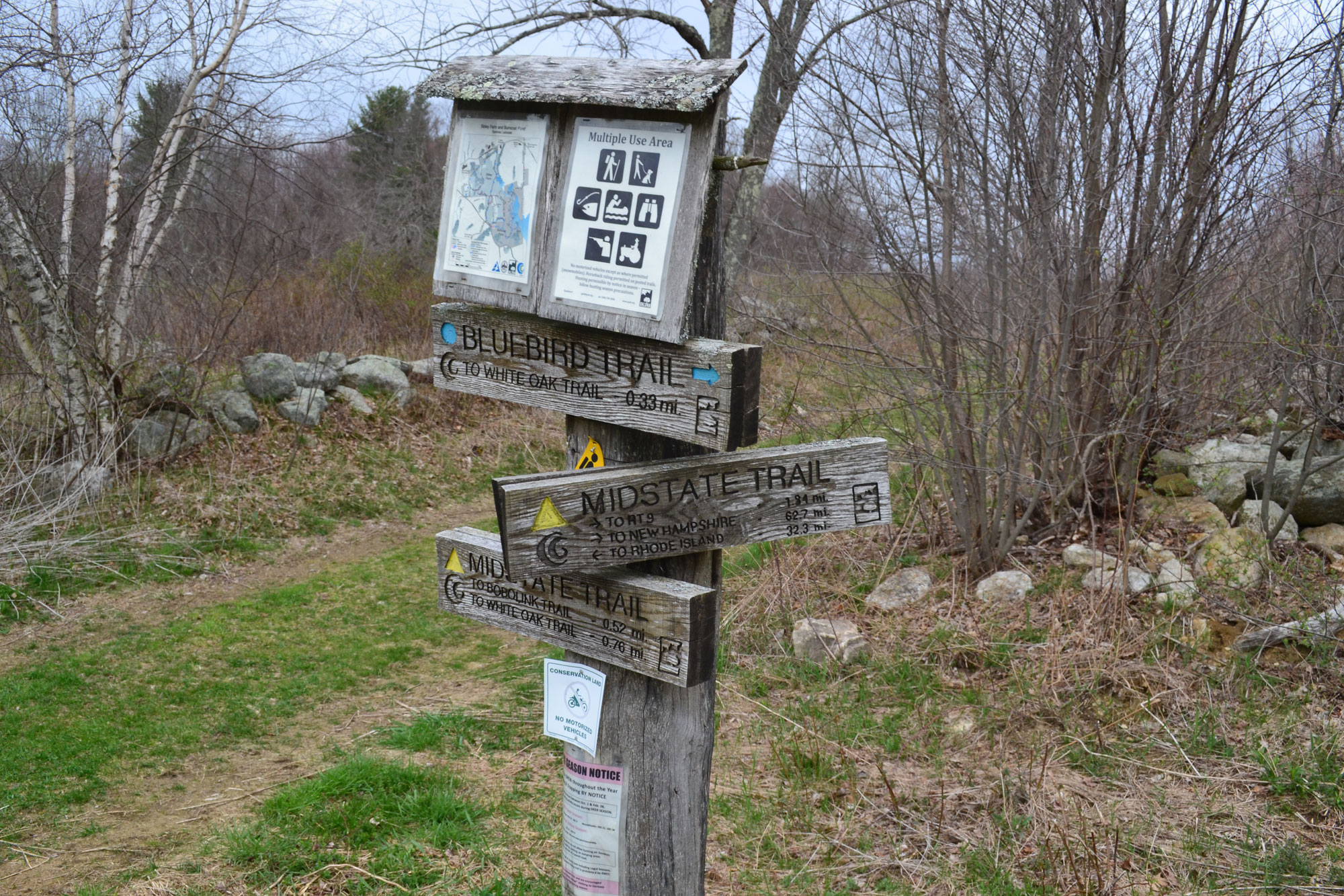
Running more than 90 miles from the Massachusetts border with Rhode Island to New Hampshire, the Midstate Trail is the premier long-distance hiking trail in Central Massachusetts. Using backroads and byways to link together many parks and forests in the Greater Worcester region, the Midstate has been a stellar close-to-home multi-day route for Massachusetts hikers since its creation in the early 1970s. Highly accessible and easy to segment, it’s as easy to section hike as it is to hike the whole thing. Here are five awesome sections, from south to north, that you should find time to explore this hiking season.
Douglas State Forest
From a granite monument at the Massachusetts-Rhode Island border, the Midstate Trail begins its northward trek in Douglas State Forest, in Douglas, Massachusetts. Located just off Interstate 395, this 5,000+ acre reservation is a “must visit” in its own right.
One way to experience the Midstate in Douglas State Forest is to park in the hiker lot off Route 16, then hike south on the Midstate for 4.1 miles to the border monument. In this region, the Midstate is easy to follow and largely flat, meandering through quiet forest. The region is lightly traveled and the hiking is pleasant, making it relatively easy to reach the monument and then reverse direction back to your vehicle.
For those looking for an even longer outing in Douglas State Forest, consider a point-to-point hike starting at the state line and following the Midstate as it makes its way north. You’ll cover the same terrain mentioned above, then cross Route 16, sticking with the Midstate as it continues through moderate, forested terrain toward North West Main Street near the Sutton-Douglas town line. Along the way, be sure to pause and enjoy the scenery at one of several viewpoints along the western edge of the Whitlin Reservoir.
Sibley Farm and Burncoat Pond Wildlife Sanctuary
Thirty-two miles from the Rhode Island border, the Midstate Trail enters Sibley Farm in Leicester, Massachusetts. Part of the Greater Worcester Land Trust, hikers can comfortably segment Sibley Farm and the neighboring Burncoat Pond Wildlife Sanctuary (a Mass Audubon sanctuary) by parking at the Farm’s Greenville Street lot. From the lot, the Midstate ascends an easy incline through historic open farmland, all the while offering sweeping views in all directions.
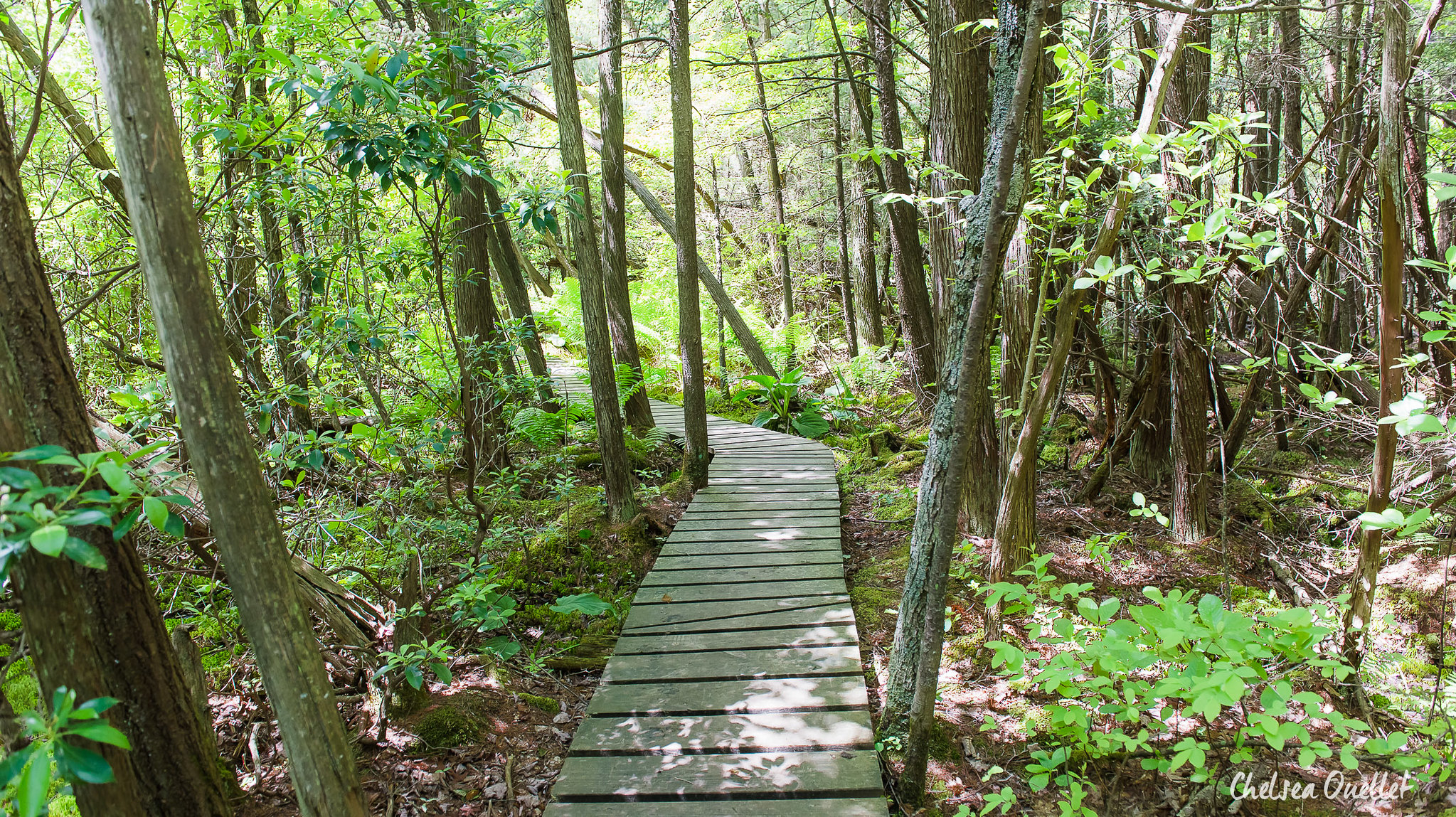
After crossing the farmland, the Midstate bends southeast into the Sanctuary, descending into a wonderland dominated by mature hardwoods and abundant mountain laurel. Here, the Midstate narrows from a wide agricultural cart path to a twisty, singletrack woodland trail, bending its way down toward the wetlands between Beaver Pond and the northern end of Burncoat Pond. Pleasant and easy throughout, attentive hikers should keep their eyes peeled for the abundant bird and wildlife populations.
From the wetland, which is near the 2-mile mark of the hike, the Midstate heads east then north, quickly leaving the Sanctuary and then joining Polar Spring Road before crossing Route 9. At any point along here, hikers can turn south on the Midstate, retracing their steps back to the Greenville Street parking area. For a different way back, consider taking the Midstate south to the junction with the Laurel Loop Trail, then following the Laurel Loop and Kalmia Loop Trails along the western edge of Burncoat Pond. On your left, you’ll have stellar views of the pond, while mountain laurel continues to dominate the scenery on the right. About halfway down the trail, there’s a boulder with a pleasant view overlooking the farm that serves as a great snacking spot. When you hit the Flat Rock Trail, turn right and meander through mature hardwoods back to your vehicle.

Mount Wachusett
At just over 2,000 feet in elevation, Mount Wachusett is the Midstate’s highest point. Located 69 miles into the Midstate Trail, it is also readily accessible from numerous nearby trailheads.
Meaning “By the Great Hill” in Algonquin, hiking to this Central Massachusetts high point via the Midstate Trail is a great family activity, with the summit offering stellar 360-degree views as a reward. On a clear day, see if you can pick out Boston’s skyline to the east, Mount Watatic and Mount Monadnock to the north, and Mount Greylock to the west.
The most direct access to the summit via the Midstate is from the Wachusett Mountain Ski Area parking lot (park near Row 6 and follow the Midstate’s triangular yellow blazes into the woods). From there, head uphill on the Midstate for two miles, following it as it takes the Balance Rock and Old Indian trails to the summit. About one-third of the way up is Balance Rock, an aptly-named remnant of the last ice age. Further up, the Midstate temporarily links up with one of the area’s ski trails, offering excellent views down toward Wachusett Lake. As you near the summit, the trail traverses through the largest known old-growth forest in Massachusetts east of the Connecticut River, with trees 150 to 370 years old, depending on the species.
For a change-of-pace descent, consider dropping south over the summit on the Midstate (also called the Harrington Trail here), following it until the Semuhenna Trail branches off to the right (northwest). This 0.56-mile trail will loop you back to the lower portion of the Old Indian Trail, in the process taking you past some of the oldest Red Oaks in the the Wachusett Mountain State Reservation. If these trees are of interest, pay particular attention just after the Semuhenna Trail branches off from the Harrington Trail.
Leominster State Forest
Just down the road from Mount Wachusett, is another highlight of the Midstate Trai: Leominster State Forest. Accessed via Route 140, this section of trail between Route 140 and Crow Hill Ledges is not to be missed. It can easily be hiked as an out-and-back in about 4 miles and 80 minutes, with excellent views back toward Mount Wachusett.
Near the turn-around point, as you traverse the ledges atop Crow Hill, look for the rock climbers below you as they ascend some of the region’s most sandbagged climbs. If you spy a climber rappelling, know that you’ll have an easier descent—the Civilian Conservation Corps built stone steps at the end of the cliff for hikers during the Great Depression. That said, wherever you decide to turn around (this is about the two-mile mark), you’ll have to ascend these steps again to get back to your vehicle on Route 140.
Once back at your vehicle, don’t miss Redemption Rock, which is located on the south side of Route 140 on a 0.25-acre site run by the Trustees of the Reservation. Here, colonists negotiated the release of Mary White Rowlandson from captivity in April 1676, after she (and others) were captured during King Philip’s War. The Midstate Trail passes right by, and Redemption Rock is a good place for the historically inclined to visit either before or after a hike on the Midstate through Leominster State Forest.
Mount Watatic State Park
The 1,832-foot Mount Watatic sits proudly near the northern terminus of the Midstate Trail. Whether you’ve hiked all 90-something miles of the Midstate to get here, or just the 1.25 miles from the trailhead parking lot of Route 119 in Ashburnham, Massachusetts, its bald, open summit is a fitting reward. Enjoy the views of the Boston skyline, Central Massachusetts, and New Hampshire’s Wapack Range.
While many know Watatic as a former ski resort (and current backcountry skiers’ paradise), it is also a wonderful hiking destination. From the lot, follow the Midstate north as it passes casually through wetlands and then, more steeply, open forest. Hikers will quickly pop out above treeline near Watatic’s summit.
For the uber-motivated, consider continuing north on the Midstate across Nutting Hill and to the granite monument marking the Massachusetts-New Hampshire border. From the marker, the 1.0-mile Midstate Bypass Trail loops hikers back to the Midstate below Mount Watatic. At that junction, it’s less than half a mile back to the Route 119 parking lot. Want to explore even more? Instead of turning back at the state border, continue along the Wapack Trail, which runs an additional 21 miles up the Wapack Range. Between the Wapack and the 75-mile North-South Trail in Rhode Island, which meets the Midstate at its southern terminus, that could be around 180 miles of hiking between the three trails.
If you have a favorite place along the Midstate Trail, we want to know about it! Tell us in the comments below.
Related Posts


