


Take on the thrilling Knife Edge trail, knock off Maine’s two highest peaks, and share the moment with thru-hikers finishing their journey to the northern terminus of the Appalachian Trail – this classic loop serves up the best that Baxter State Park has to offer.
Katahdin stands alone as the single most challenging peak in the state of Maine. From Maine to Georgia and beyond, Katahdin has been one of the Northeast’s premier hiking destinations ever since the Appalachian Trail was completed in 1937. This loop tackles five notable summits in the heart of Maine’s fabled Baxter State Park. You will pass by cascading brooks, alpine lakes, spectacular panoramic views, and miles of scrambly travel above tree-line. Whether you’re a long-distance backpacker, a peak bagger, or just someone looking for the best hiking that New England has to offer, a trip to Katahdin has adventure written all over it!
Quick Facts
Distance: 11.8 miles, round-trip
Time to Complete: 10 to 12 hours for most
Difficulty: ★★★★★
Scenery:★★★★★
Fees/Permits: $15 per car for out-of-state visitors, Maine residents with ID are free
Contact: https://baxterstatepark.org/
Turn-By-Turn
Baxter State Park, which holds Katahdin, is most easily accessed via Millinocket, Maine. To get there, you’ll take Interstate 95 to exit 244, then wind your way west on route 157 through the logging communities of Medway and East Millinocket until you reach “Maine’s biggest small town”. The trip generally takes about 5 hours from the Boston area, and basic lodging and services such as gas and groceries can be found in town. The Togue Pond gatehouse is the only local way to get into the park by car, and it opens at 6AM. Camping or sleeping in your vehicle at the gatehouse is not allowed.
Red Tape
Getting to the park is by far the easiest part of this trip. Baxter State Park has a limited amount of trailhead parking, so in recent years they have implemented a strict parking reservation system. Be sure to keep an eye on the park’s reservation pass website to ensure you have a spot waiting for you when you arrive. This loop starts at the Roaring Brook trailhead, so be sure to reserve a spot four months in advance of your hike or you will risk passes being sold out. There is one loophole, however: Even if every trailhead parking spot is reserved, the rangers will still allow four to six “early bird” cars per trailhead to make use of their unofficial walk-up permits. This is handy knowledge to have, and if you make it to the Togue Pond Gatehouse between 4 and 6AM, you can usually park in line and hope to get lucky. If you are lucky enough to have a trailhead reservation, just remember that these reservations expire at 7:05 AM and you will lose your spot if you’re not in line by then.
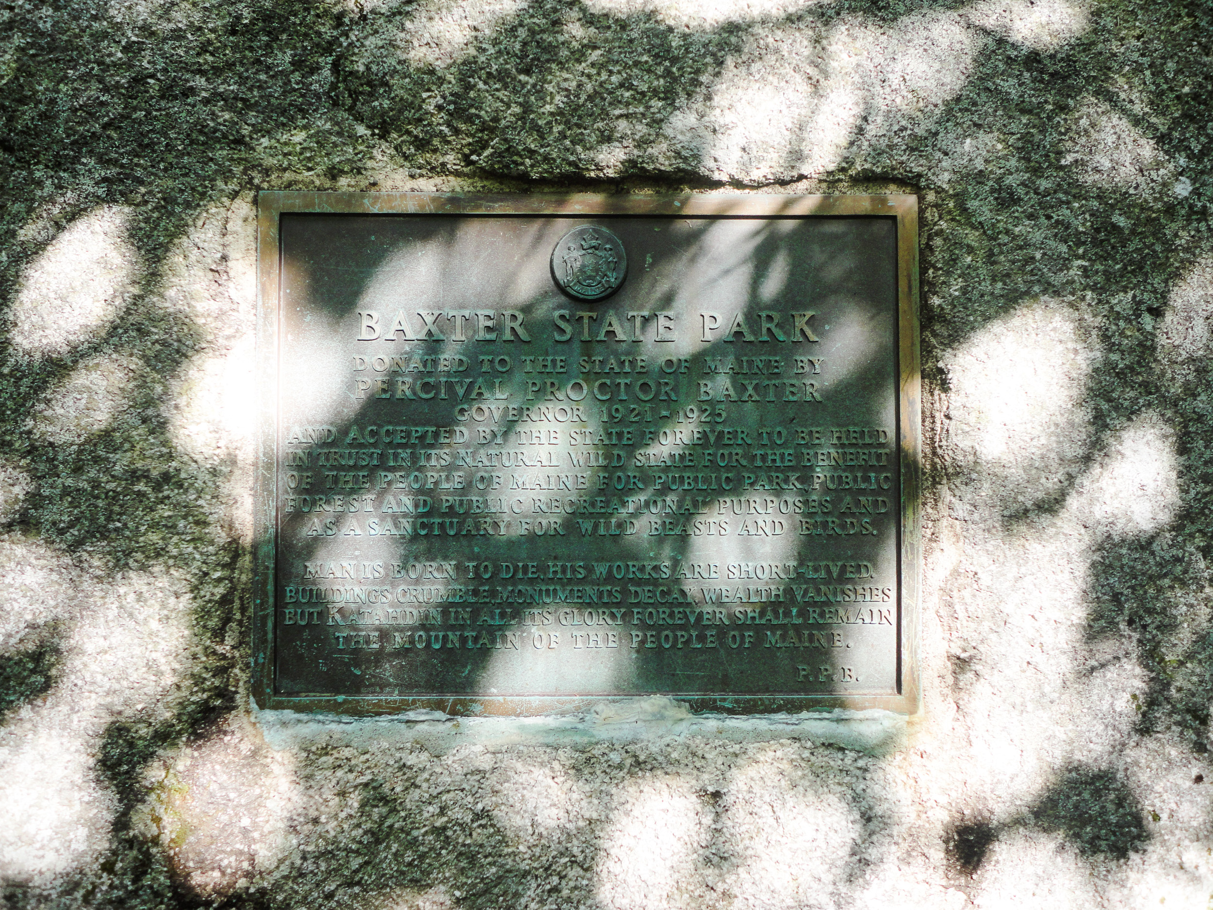
The other red tape to be aware of is that Baxter State Park has some seriously old-fashioned rules and regulations. The lands in the park were gifted to the state by former Governor Percival Baxter between 1931 and 1962, and as such are required to remain “forever wild.” This means that you will have to abide by such arcane regulations as no pets allowed, no power equipment such as chainsaws, generators, or Bluetooth speakers, no public consumption of alcohol, no drones, no children under the age of 6 above tree line on Katahdin, and no wearing of white cargo pants after Labor Day. Okay, I made that last one up but you get the idea.

Hit the Trail
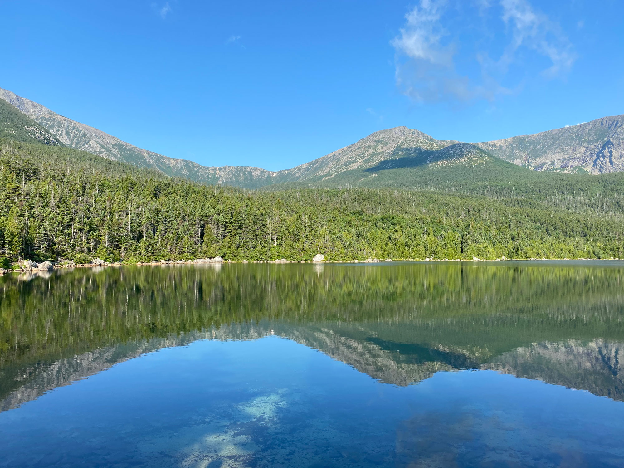
Roaring Brook trailhead (45.91944, 68.85737) has a campground, a ranger station, and outhouses at the parking area, but don’t expect to find potable water. Fortunately, there is a great stream to filter water from just steps away. Sign in at the trailhead register here and head west up the Chimney Pond trail along the southwest bank of the river. The trail starts out quite mellow and you will immediately pass the Helon Taylor trail junction on your left. This will be the trail that you finish your loop on, and if poor afternoon weather conditions are forecast you may want to do this loop in reverse. The Chimney Pond trail continues along and eventually leaves the stream behind, traversing through the trees and gradually gaining elevation on a rocky footpath. You will cross a stream that drains Pamola Pond at mile 1.0, and at mile 2.1 you will arrive at Basin Pond (45.92114, 68.89239). This is a great spot to stop for a snack and to take in a breathtaking view of the mountain ridges that you will soon be climbing.
Continue onward and upward, passing the North Basin trail at mile 3.0 and arriving at Chimney Pond Campground at mile 3.3 (45.91541, 68.91196). This spot may be one of the highlights of your trip! Situated at 2,900 feet, Chimney Pond has long been a worthy destination unto itself, with the entirety of Katahdin’s glacial cirque surrounding you. There is another ranger station here, as well as a bunkhouse and a handful of lean-tos for campers that have reserved sites. Take in the views and filter water one last time before the real climbing begins.
Hamlin Ridge
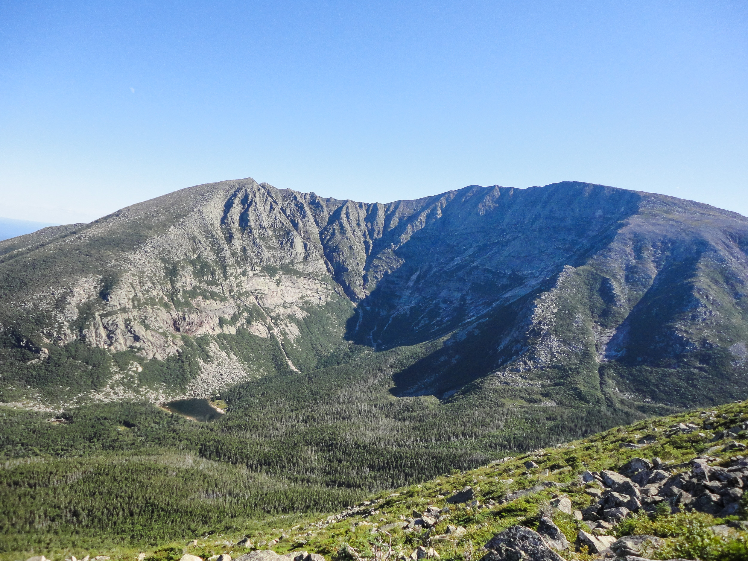
The next leg of this loop back-tracks 0.3 miles to the North Basin Trail and continues through a spruce forest for less than half a mile to reach a large cairn marking the Hamlin Ridge trail on the left (45.92297, 68.90857). Follow this trail steeply uphill until you break treeline and get the payoff for which this loop is known for. You will climb over 1,700 feet in 1.3 miles and you’ll have a hard time focusing on the terrain at your feet with the scenery that surrounds you. The trail climbs up and over boulders and open rock slabs to the crest of the ridge, leaving the trees far below and eventually ascending to 4,756-foot Hamlin Peak, Maine’s second highest official 4,000-foot-er.
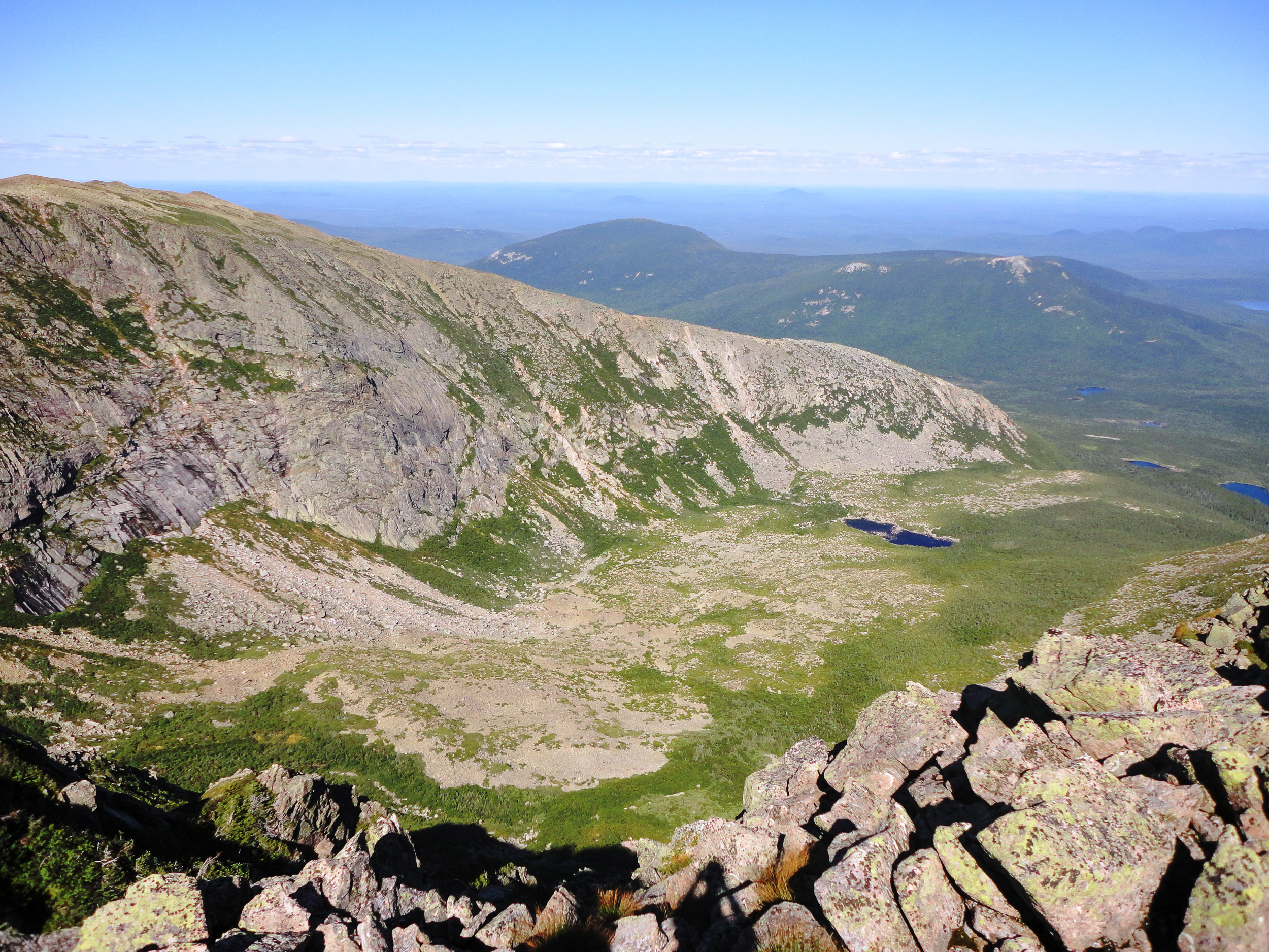
Most people would consider Hamlin Peak to be a full value day in and of itself, but how could anyone stop when Maine’s crown jewel is only 2.2 miles and 1,000 feet of elevation gain away? Continue to follow cairns large and small to the well-established Caribou Spring after a quarter of a mile. This spring is generally a reliable place to find water if needed, and its cold water is remarkably pure. Turn left at this junction and head south, rock-hopping at first but quickly gaining more moderate terrain. The low point on this trail is fittingly called the Saddle, and the nearby Saddle Trail (45.91388, 68.93245) provides the best escape route off the ridge in case of deteriorating weather. If needed, the Saddle trail descends 0.9 miles down steep and loose gravel to Chimney Pond, and 3.3 miles back to the original trailhead.
Baxter Peak
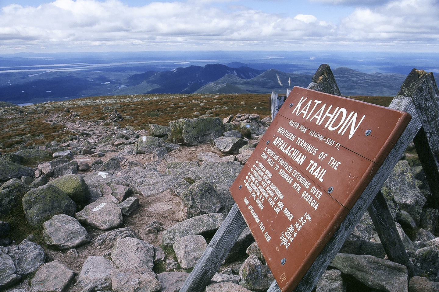
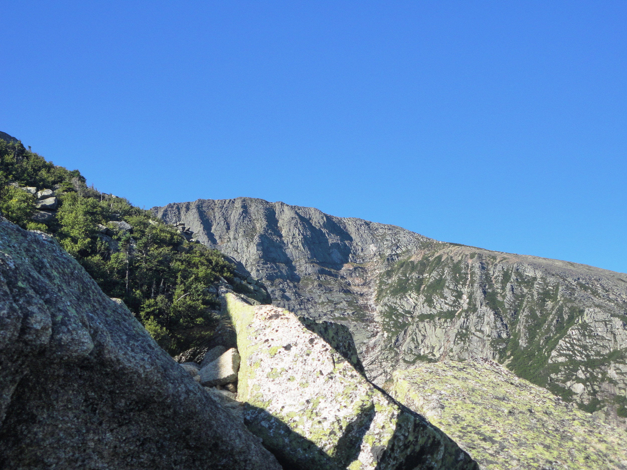
Continue to follow the main trail up the ridge, passing both the Cathedral cutoff and the Cathedral trails en route. This last mile climbs steadily on a well-constructed trail of pink granite, and Mount Katahdin’s well-known summit sign finally appears to greet hikers from near and far. Take your time to enjoy the sweeping views that surround you, as AT thru-hikers approach across the Tableland and distant lakes sparkle in nearly every direction. Chimney Pond can be seen far below and the daunting Knife’s Edge trail presents itself as the crux of this loop.
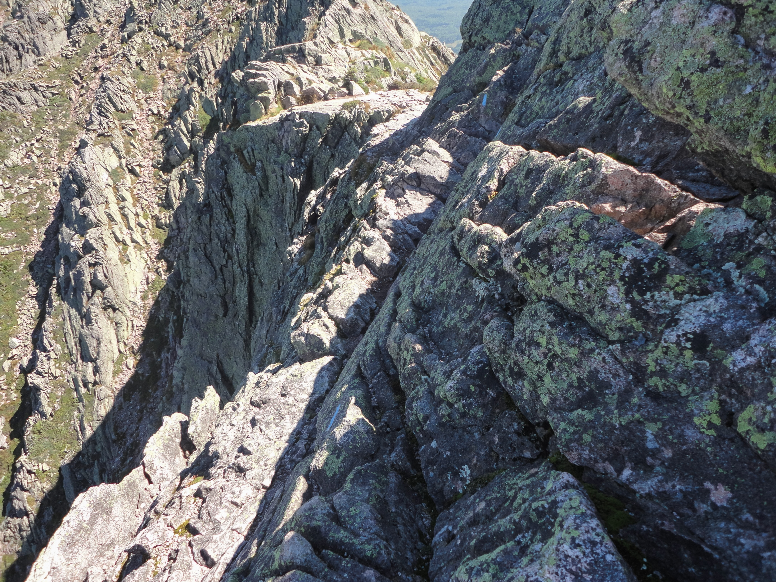
The Knife Edge
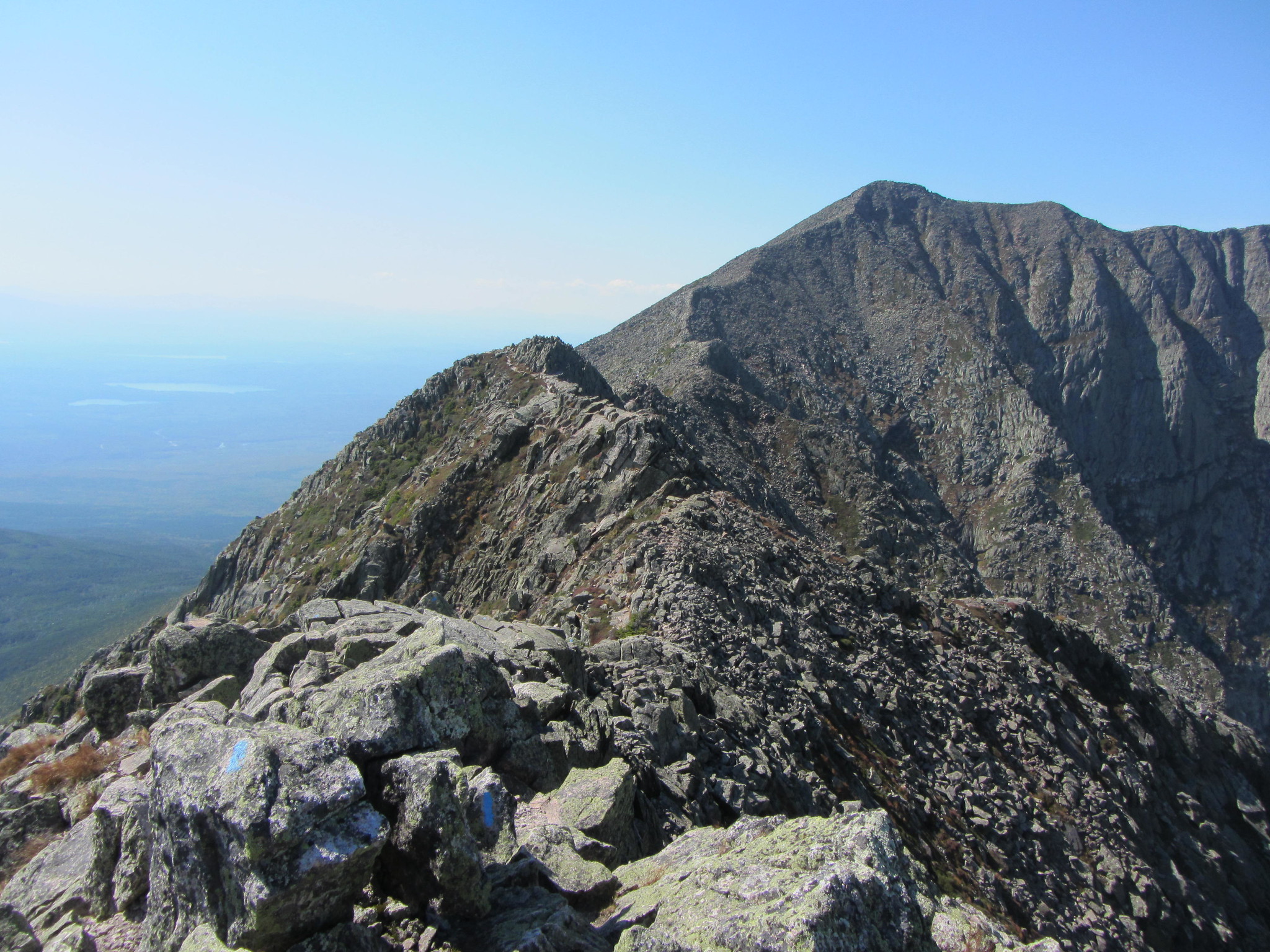
As you leave the summit along the Knife Edge, the first landmark will be Katahdin’s South Peak (45.90208, 68.91685). This airy perch offers an equally stunning view of the surrounding terrain and immeasurably more solitude. Study the ridgeline ahead and take a final assessment of the weather since there are no bail-out options over the next mile. Follow the blue blazes along the rocky arete, carefully making your way down towards a high saddle on the ridge towards Chimney Peak. As you approach the peak, the difficulty kicks up to third-class scrambling, eventually culminating with a few semi-exposed moves that could spell disaster for a less sure-footed climber. Trekking poles will come in handy to keep your balance but you may need to stow them at times while clinging to the rock with both hands. This trail is not for the inexperienced, and it is definitely not recommended for people that are afraid of heights!
Once on top of Chimney Peak (45.90525, 68.90649), the single most difficult move of the traverse will present itself. There is a narrow notch that separates Chimney Peak from Pamola Peak, and the descent into this notch involves downclimbing a precarious ledge to a foothold on a boulder below. Once past this spot you can breathe a little easier, and the climb up to Pamola Peak’s summit is short, steep, and trivial by comparison. This final major peak on the Baxter-Hamlin circuit affords a fine line of sight over your entire route thus far, with a particularly impressive perspective of the Knife Edge in all its glory.
The Descent
Here you will find a large cairn with a trail junction for the Dudley and Helon Taylor trails (45.90613, 68.90606). The Dudley trail drops steeply to the north and heads straight back to Chimney Pond. The better option will be to continue following the blue blazes along the Helon Taylor trail, following the spine of the Keep Ridge and eventually below tree line. This trail has a mixture of loose gravel, bare rock slabs, and steep, eroded trail that will keep you on your toes. The route eventually drops below treeline and crosses a small brook, and after 3.2 miles you will rejoin the Chimney Pond trail and arrive at Roaring Brook campground soon thereafter.
The Kit
- The AMC’s Maine Mountain Guide is an invaluable resource, complete with detailed trail descriptions and waterproof maps.
- Leki Makalu Lite Cor Tec trekking poles are a game-changer. Their unique palm-friendly handle, combined with strong yet lightweight aluminum and a lifetime warranty makes these your new go-to pair.
- Get a grip on this loop’s gnarly trails with the Salomon Speedcross 5. These trail runners will give you the edge when you need it most.
- Make every thru-hiker jealous with a fresh pair of Farm to Feet’s Harper’s Ferry ¾ crew. This ultra-durable wool-nylon blend is super comfortable, won’t stink, and it even rocks the Appalachian Trail logo!
- We all know that mountain weather could change in an instant out on the trails. Be sure to pack a lightweight EMS Thunderhead Peak rain jacket for protection from the elements in a pinch.
- MSR’s handy TrailShot water filter is always ready to clean up your hydration situation when you need it. Just drop the tube with built-in pre-filter into a water source and pump out clean water in no time flat.
Keys to the Trip
- Make your way to the Togue Pond Gatehouse as early as you can. Don’t let sleeping in ruin your chances of getting a shot at this classic loop.
- You’ve got a friend in ME. If you are fortunate enough to have any hiking buddies from the great state of Maine, bring ‘em along—Entrance to the park is free as long as someone in your group has a Maine ID.
- Listen to the rangers. The stewards of Baxter State Park are some of the best in the business, and they know when the weather isn’t looking good for travel above treeline. If Katahdin’s a no-go, there are plenty of other peaks in the park to visit such as South Turner, Doubletop, or North Brother.
- This hike is a serious undertaking and many hikers underestimate it. Both the hike and the drive home will take longer than you expect, so consider booking a campsite or a room back in town to rest up and refuel after a long day. Wouldn’t want to hit a moose on the drive home, would ya?
- Kick off your shoes and take a dip in the crystal-clear waters of Upper Togue Pond after your hike. Take note of the parking area and sandy beaches just after the park entrance on your way in – it’s a great spot to rinse off and get refreshed before you head back to town.
- Keep Maine beautiful. There’s a glacial erratic on the side of Baxter Park Road that Mainers have been painting a mural of Katahdin on for years. Pull over and get a picture with this local landmark, and keep your eyes peeled for wild Maine blueberries that grow everywhere along this stretch road in early to mid-summer.
Current Conditions
Have you done the entire loop or even a piece of it recently? Post your experience and the trail conditions (with the date of your hike) in the comments for others!
Related Posts


