If braving Acadia National Park’s crowds in Bar Harbor, Maine—with its lines of cars creeping up the road toward the summit of Cadillac Mountain—turns you off, consider going to the other Acadia National Park, on Isle au Haut. It couldn’t be more different, nor could it be more perfectly Maine.
We did both this summer. The hiking on Isle au Haut stands out as a beautiful memory of our trip, while Cadillac Mountain was less special due to the crowds. My partner John and I relish remote hikes, and because it’s hard to get to, Isle au Haut is about as remote as one can get within New England.
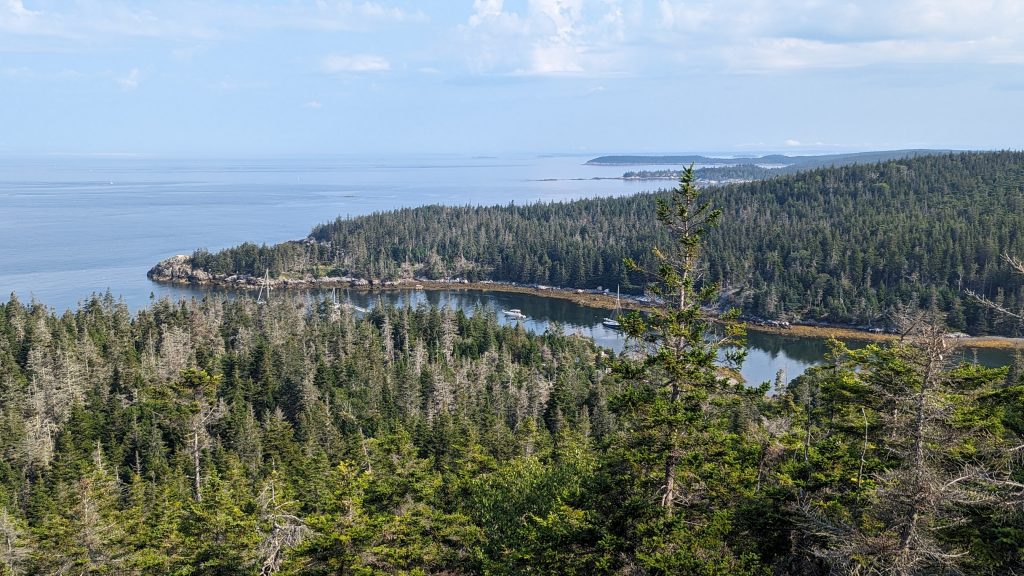
Isle au Haut is a 12.5-square-mile, roughly rectangular-shaped island just south of Stonington, Maine, and accessible only by boat. Fewer than 100 people live there, primarily on the northern end. For those hoping to experience the solitude of nature, there’s good news: there are no ice cream or t-shirt shops and no cruise ships disgorging passengers. There’s nearly zero automobile traffic too, but there are miles of rugged hiking trails with spectacular coastal views. This portion of Acadia National Park was donated in the 1940s by descendants of the earliest European inhabitants.
How to Get to Isle au Haut
There’s a “mailboat” ferry from Stonington, on Deer Isle, that runs to the island daily, year-round, stopping at the town landing. From about Memorial Day to October 1, the ferry also goes to Duck Harbor, a small inlet on the lower western side of the island closer to trailheads and the five seasonal National Parks campsites (reservations are required). Due to the ferry schedule, it’s a good idea to plan on camping if you want to enjoy most of the trails. The approximately 9 a.m. arrival and 4 p.m. departure of the boat at Duck Harbor provides a decent amount of time to explore for day hiking, but with 18 miles of intoxicatingly beautiful trails available—not to mention an opportunity to sit under the stars at night—camping is a tempting option.
Note: It’s possible to access trails from the town landing, but it’s a four-mile hike to the Duck Harbor area. A round-trip ferry ticket for an adult is $44.
Planning for Peak Views
We arrived at Duck Harbor’s landing in late July and ventured ashore for the day. After traveling so far and sitting too much, we were ready to stretch our legs on a challenging hike. These trails did not disappoint.
From the trailhead near Duck Harbor, John planned a route to include most of the trails on the southern end of the island for a looping 8-mile trek that took advantage of the great ocean views. We started by scrambling over glacial rock toward the “summit” of Duck Harbor peak, 300 feet above sea level. This trail tested our legs from the beginning with lots of short, steep up- and down-hill segments. It was hard at times to follow the blazes—mostly because the views of the ocean were so distracting. I was amazed by the chunky granite boulders that formed mini ravines in the interior of the island. The topography suddenly made it clear why the first European settlers in the mid-1800s gravitated to the flatter, northern part of Isle au Haut for their sheep farming and homes. Before that, Native Americans heaped piles of shells on the shoreline.
As we moved south on Duck Harbor Mountain Trail, we could see fingers of fog slipping around dark green fir trees near the shore. The sun peeked through overhead from time to time, heating us up quickly as we moved from exposed rocks to cooler groves of evergreens.
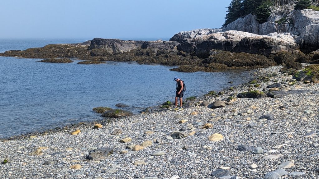
The trail ended at Squeaker Cove, a narrow, rocky inlet that faces south. We took in the forested ledges that curve around the edges of the cove, and the debris washed ashore over the years: twisted lobster traps, tangles of colored rope, and pieces of lumber. Instead of a sandy beach, here there are cobbles: millions of rocks that make a satisfying “whoosh” sound when waves lap against them.
From Squeaker Cove we turned right (west) and took the Goat Path to Deep Cove, then turned right again on Western Head Road, an unpaved track that took us north back toward Duck Cove. The unpaved roads were relatively flat, with this one offering a soft grassy surface (the last one we walked on gets more use and is gravel). We strolled up the road to the first left, Western Head Trail, which turned southwest, back to the shoreline after a brief flat period in a wooded area.

Following the Shoreline
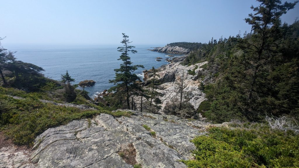
Western Head Trail follows the contour of the elevated southwestern corner of the island, also known as a “head.” There’s another “head” on the southeastern side, and each head has a small rocky island offshore called an “ear” (Western Ear and Eastern Ear). Whether these names are some forgotten maritime terms or concrete evidence of dry Maine humor, I don’t know. In any case, there’s no debating that the trail is spectacularly scenic as it traces the outer edges of several rocky inlets in a scallop pattern. Between each cove is just enough time in a woodsy fringe to make the unveiling of the next scenic slice of shoreline worth gasping about.
Rocky beaches and tumbling waves weren’t the only attractions on this hike. When the trail bent away from the water, it wound through the cool shade of evergreens where we found brightly colored mushrooms, and then back into the sun where there were patches of raspberries and blueberries. Sadly, we saw other people on the southern side of the island. Four of them. Fortunately, they weren’t interested in the wild berries, nor were they talkative, so I could pretend I didn’t see them. I prefer the fantasy that John and I had the island and its fabulous trails to ourselves.
When we reached the southernmost point of the island, we turned left (northeast) and continued to follow the breathtaking shoreline trail over some boardwalks and through clusters of spruce to its end at Barred Harbor. Here the southern shoreline was even more dramatic, with huge chunks of granite split cleanly to create hurricane holes that the ocean must crash into during storms. Along the way, we located a clear spring that was suitable for filling water bottles, but which we used to cool off. The fog had been driven away by hot sunshine and wind was nonexistent.
Better Planning Next Time
The only unpleasant part of our hike was the next section, which followed the western side of the Merchant Cove wetlands on the Median Ridge Trail. This portion was boggy and seemed poorly planned as it passed directly through the wetland without bog bridges. After we cleared the top of the cove, there was a boardwalk across standing water, leading me to wonder if the lower portion was mismarked as a trail or perhaps a future site of a bog bridge. Either way, there were tons of dragonflies and butterflies in the wetlands area, which were nice distractions from our wet feet.
We hoped to hike further north, to Bowditch Mountain and to Long Pond, which parallels the eastern shore of the island, but when we reached Duck Harbor we were done. It was a hot day and the terrain was more challenging than we anticipated. We jumped off the mailboat’s dock to cool off and began planning for our next visit and the chance to explore the remaining trails.