


Extreme cold, deep snow, and closed access roads make climbing Katahdin during the winter months a real expedition.
Mount Katahdin is a granite massif that is home to several peaks including Baxter Peak, the highest point in Maine. It is the northern terminus of the Appalachian trail and presents a steep glacial cirque unlike other peaks in the Northeast. The remoteness and near arctic environment of Katahdin make it one of the more challenging, but also one of the most rewarding winter summits in the Northeast. Most climbers choose to tackle this one as an expedition-style climb with a night or even two spent camping, while very fit and intrepid hikers do tackle it in one extremely long day.
Quick Facts
Distance: 17 miles, round-trip
Time to Complete: 2-3 days for most
Difficulty: ★★★★★
Scenery:★★★★★
Fees/Permits: Strict permitting and reservation requirements. See explanations below.
Contact: https://baxterstatepark.org/
Red Tape
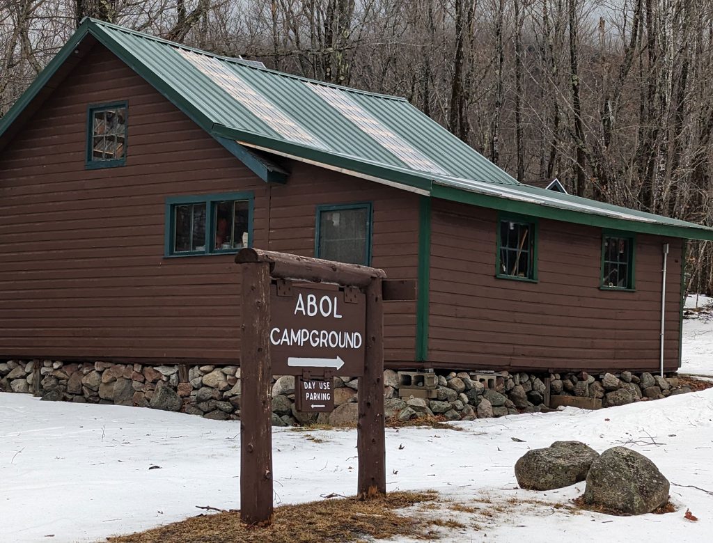
Baxter State Park (BSP) has strict rules for access in winter. Prospective climbers must first submit a Winter Use Registration Form with BSP. This form is approved at the park’s discretion, must be submitted at least a week in advance, and asks for many details including the participant’s specific winter climbing experience, and exact gear particulars. This level of scrutiny is justified as Katahdin is a very remote and unforgiving peak that has been home to over 60 fatalities. In addition to the Winter Use Registration Form, most who will choose to overnight on their trip must also make winter camping reservations. Winter reservations can only be made in person or by mail, requests are usually accepted starting in early November, and some locations fill quickly. Those who want to be out of the elements can choose to reserve bunkhouses or cabins at Daicey Pond or other locations, but this will add additional mileage to the trip described. Lean-to reservations at Abol Campground will be the most direct, but campers will have to be prepared to be exposed to the elements, although fires are allowed. The BSP website had many more details on these processes and rangers are good about answering questions by phone as well.
Getting There
In winter when most of Baxter State Park closes down, one of the nearest access points is Millinocket, Maine. To get to Millinocket use Interstate 95 North to exit 244, and then use Route 157 West. The drive is about five hours from Boston or three hours from Portland. It is a small town but has basic food, lodging, and gas services. You may find better accommodation options through sites like Airbnb, especially for groups. The Appalachian Trail Cafe and the Scootic In Restaurant are a few reliable if not amazing food options for breakfast and lunch respectively.
Turn-by-Turn
The trailhead is the Abol Bridge parking area which is almost 20 miles from Millinocket, mostly on the famous Golden Road. This is a dirt road that is often very icy in winter and you should ideally have four-wheel drive and snow tires for the rough drive in. In addition, watch for active logging trucks which frequent the route. From here, proceed across the road, and head into the park by making your way a short distance (.3 miles) along the Appalachian Trail before turning right onto the Abol Stream Trail. After a little over a mile along the flat and uneventful Abol Stream Trail, you will cross a small bridge over the outlet of Abol Pond, and pass by the Abol Beach area before finally reaching the main Park Tote Road at the 2-mile mark. While this initial trail approach may be host to a variety of trail conditions from ice to deep snow, the Tote Road is typically packed down from snowmobile traffic unless there has been a very recent snowfall. Turning left on the Tote Road you will proceed another 2.5 miles with about 600 feet of steady elevation gain to warm you up before reaching Abol Campground and the start of the Abol Trail and the real work.
The Climb
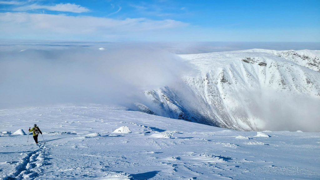
Once at Abol campground, those who are camping will set up basecamp at the lean-to they reserved. A ranger station is located here, the porch has weather and other updates posted, and they will often check in with you. Just past the campsite area, the Abol Trail proceeds up to the Abol Slide and onto the high plateau of Katahdin. The trail starts off in pretty birch woods and gets progressively steeper as it rises. A little over a mile in, as the trail nears treeline, the new Abol Trail departs the slide proper and winds around the steepest section before meeting back up with the slide. This new trail section was created after a serious landslide closed the Abol Trail in 2014 and it was rebuilt. The final half mile of the trail climbs very steeply out of the slide and up a long stretch of steep boulders that grow to the size of cars at times. This section can be very tricky in certain conditions. Deep snow or icy conditions can require the use of snowshoes or full crampons and ice axes. Weather is also a serious consideration as this part of the climb as well as the tablelands above are very exposed to the elements.
Almost There
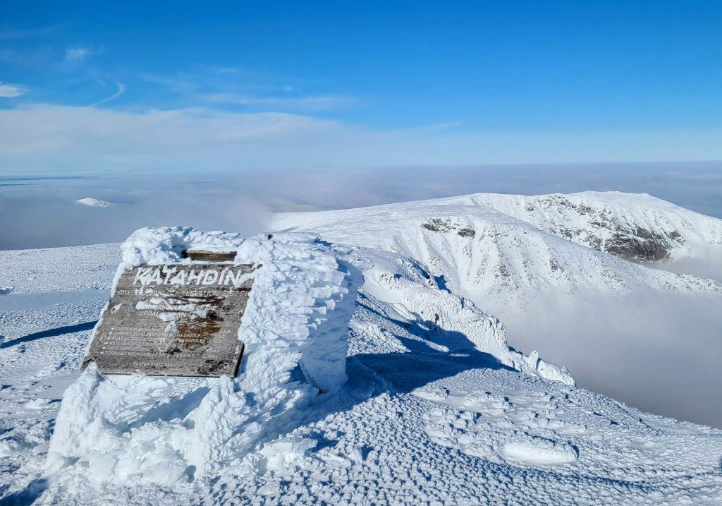
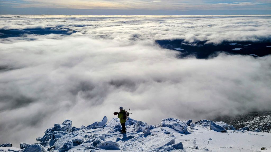
If you have taken time to stop looking straight up at the rocks, and if you are lucky enough to have clear skies, you would have noticed wonderful panoramic views of Maine’s north woods wilderness opening up behind you. As you reach the top of the tablelands, a large high-elevation plateau, you will come to an intersection where you turn right to head to the Baxter summit. You are now on the AT again and have just under a mile, and about 600 feet of steady climbing to reach the summit. This area is totally bare of shelter and climbers need to be very mindful of weather while exposed. In addition, the summit area is very prone to whiteout conditions in winter so as always when above treeline it is wise to take a compass bearing, use GPS to track your location, keep an eye out for occasional cairns, and stick together. If not buried under the snowpack or rime ice, you will see the famous wooden sign that provides a picture point for so many AT hikers. Just a few steps beyond, the summit provides jaw-dropping views across the knife’s edge to Pamola Peak and over the South Basin to neighboring Hamlin Peak. From here it is a retrace of your steps to either camp or the long slog out to your car!
The Kit
- Most who are making this journey an overnight endeavor will choose to pull a pulk sled full of gear rather than an oversized pack. You can purchase a sled or build your own with cheap materials and a quick YouTube search. Just be mindful that the approach trails don’t always provide ideal conditions for pulling a sled.
- Be prepared for a very cold overnight with a proper winter camping sleeping bag rated to 0° F or lower. The EMS Mountain Light 0 is one good option. Add a liner for extra cold forecasts.
- You will want to have true crampons on hand for situations where the Abol Trail is icy or frozen. The Petzel Irvis Flexlock provide one lightweight option that can be used with any boot.
- While not absolutely necessary, if the forecast calls for extreme cold, if you are going to anticipate a long day in crampons, or if overnighting, a light double mountaineering boot like the La Sportiva Baruntse works well, and allows for use of a full crampon if desired.
- With much of the climb above treeline and exposed to winds and glare, proper eye protection like the Giro Blok goggles are good to have on hand.
Keys to the Trip
- Your success on Katahdin is dependent on a great deal of variables like weather and trail conditions that cannot often be controlled or predicted. Therefore, whenever possible, give yourself an extra day or two on your reservations to allow flexibility to choose the best summit day.
- Many who choose to climb Baxter Peak also have an interest in summiting nearby Hamlin Peak, another Maine 4,000-foot mountain. Realize however that this will add approximately 6 miles and nearly 1600 feet of climbing, all of it above treeline and exposed on the upper plateau, so choose wisely.
- Other options for approaches do exist. Climbing from the Chimney Pond area allows for the use of bunkhouses or cabins and multiple trail approaches to Katahdin. However, this means a longer hike into camp and harder reservations to obtain.
Current Conditions
Have you hiked Katahdin recently? Post about your experience and any tips you have in the comments for others!
Related Posts


