


With an excellent network of trails and Downstate New York’s finest rock scramble, Breakneck Ridge in Hudson Highlands State Park is a must for hikers and trail runners in the Northeast.
Breakneck Ridge is an absolute must for northeastern hikers and trail runners. While its exposed, rocky scramble—which gains a whopping 1,250 feet of elevation in 0.75 miles—is the undisputed headliner, the network of trails in Hudson Highlands State Park that it provides access to is an incredible resource.
Quick Facts
Distance: 3, 6, or 9 miles
Time to Complete: 1.5, 3.0, or 4.5 hours
Difficulty: ★★★★
Scenery: ★★★★
Turn-By-Turn
Getting There
From I-84, take exit 41 for NY-9D, Beacon/Wappingers Falls. Turn onto NY-9D South and continue for 6.4 miles. Parallel, roadside parking is available, as posted, in both directions. Park on either side and walk south, taking care as NY-9D is a relatively busy highway. The well-signed trailhead is on the right-hand side of the road, just before the entrance to Breakneck Tunnel (41.44347, -73.97796).
On a fair weather Saturday or Sunday morning, Breakneck Ridge’s popularity becomes immediately apparent. From the trailhead at Breakneck Tunnel, cars line both sides of the highway for as far as the eye can see. Hikers are everywhere. There’s a small village of port-a-potties and, sometimes, there is even a line of food trucks. For a humble trailhead, this one garners a lot of attention.
The loop hikes that follow all begin with the multi-part scramble up Breakneck Ridge, each branching off the Breakneck Ridge Trail (BRT) at a different location and eventually circling back to the trailhead via the Wilkinson Memorial Trail (WMT). The loops offer three unique experiences and range in distance from three to nine miles. Although these loops are all stellar, they’re but a few of the options the park provides.
Starting The Scramble
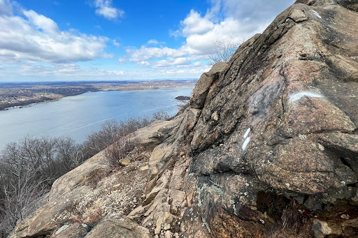
Right from the very first step, the white-blazed Breakneck Ridge Trail gets down to business: your first task is clambering up a short grade to the right of the tunnel entrance. A partial, seasonal view across the Metro-North tracks and the Hudson River opens up before the trail turns back sharply to the left, crossing the highway over the tunnel itself.
Here the fun begins—as the grade steepens, the terrain roughens, and the pace slows. Keep your eyes on the white blazes (sometimes reflective discs mounted to trees, sometimes paint on the rock) as you high step, pull with your hands, and generally fight your way up the trail. The ridge becomes more exposed the higher you go until you reach the first of the scramble’s few flat areas, an outlook marked with a flagpole, at 0.3 miles.
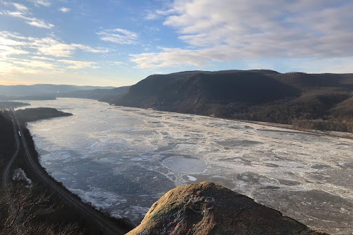
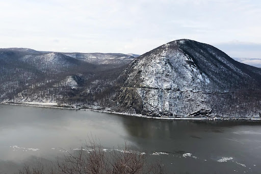
A stellar panorama is found at the flag pole, with Storm King Mountain front and center, directly across the river. To the south, Little Stony Point marks the southern border of the park, at the Village of Cold Spring; to the north, Pollepel Island—recognizable by the ruins of Bannerman’s Castle—and the Newburgh-Beacon Bridge. This is as good a place as any to take a break and gird oneself for the climb to come.
The Scramble Continues
The trail resumes its ascent, climbing to a junction with the green-blazed Nimham Trail at mile 0.3 (41.44281, -73.97545). Immediately after this junction, the BRT splits—to the right is the trail proper; to the left is an alternate route marked “Easier Ascent” (41.44309, -73.97461).
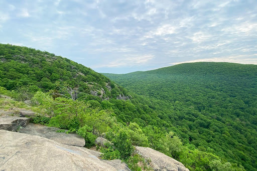
Continuing on the regular route, negotiate a technical move or two to gain another outstanding view back across the Hudson River. The number of times you’ll feel compelled to take your camera out is among the chief challenges presented by this segment of the trail—perhaps even more so than the scrambling.
When ready, climb on, to another photogenic viewpoint at mile 0.4 and a second, marked, “Easier Ascent” option at mile 0.5 (41.44382, -73.97319). Keep on climbing, up and over a minor knob, until the trail finally relents and descends to a junction with the yellow-blazed Undercliff Trail (41.44585, -73.97168) at 0.7 miles.
While the Undercliff Trail descends steeply to the right, skirting the base of the dramatic, sheer cliffs that make up the ridgeline’s southern aspect, to continue on your loop, stay straight on the Breakneck Ridge Trail, following the white blazes.
Time to Choose
At mile 0.9, the last of the scrambling is over, and the BRT drops into the trees. Press on as it descends, then climbs another knob, before descending again. At 1.4 miles, the Breakneck Bypass Trail—announced, in no uncertain terms, by red spray paint—breaks to the left (41.45383, -73.96621). Continuing on the path of least resistance, as signed, is the way to go. And though the more difficult sections of the BRT are perfectly passable in wet or icy conditions, this bypass will be welcome to the timid or the unprepared in foul weather.
To access the first of the loops (the three-miler), take a left on the Breakneck Bypass Trail. For the six- and nine-milers, you’ll stay on the Breakneck Ridge Trail for a while longer.
The Three-Mile Loop
The three-mile loop departs the BRT at its junction with the Breakneck Bypass Trail. Follow the red-blazed Breakneck Bypass Trail as it climbs over a rocky knob before swinging to the left, and beginning to descend—the final descent of the hike. Continue on, gradually losing elevation and negotiating some brief moments of rock hopping, until the trail terminates at 2.2 miles, at its junction with the yellow-blazed Wilkinson Memorial Trail (41.45331, -73.97648).
This is the home stretch: a leisurely stroll on the Wilkinson Memorial Trail’s non-technical terrain all the way back to the road. If you’re running, it’s the ideal setting to hit the gas and make up some time lost on the steep, opening scramble. Let it rip, passing a junction with the Nimham Trail (41.44885, -73.97921), until you hit the WMT’s western terminus (41.44788, -73.9804) at NY-9D. Head back to the car, along the road to complete the loop.
The Six-Mile Loop
Getting to the six-mile loop requires staying on the Breakneck Ridge Trail a little longer. From its junction with the Breakneck Bypass Trail, continue straight on the BRT, over rolling terrain, for another 0.2 miles to its junction with the blue-blazed Cornish Trail (41.45566, -73.96293). Stay straight on the BRT as it rolls over relatively flat terrain, breaking to the left around the ridge’s high point before gradually descending to a junction with the green-blazed Breakneck-Wilkinson Connector, on the left, at mile 2.8 (41.46851, -73.95453). Take the Breakneck-Wilkinson Connector as it descends a wide, graded woods road for a quick 0.1 miles to its junction with the yellow-blazed Wilkinson Memorial Trail. (41.46965, -73.95613).
The Wilkinson Memorial Trail provides ample opportunity to get the blood pumping—the first of which comes as soon as you hang a left. Push on, over rolling terrain and the odd technical moment. In winter, without leaves, you’ll have lovely partial views back through the trees of Breakneck Ridge to the left and Sugarloaf Mountain to the right.
At mile 4.3 of the six-mile loop, the WMT reaches Sugarloaf Mountain and breaks hard to the left. From here, a spur trail used to continue up to Sugarloaf Mountain’s summit, but after a forest fire in 2019, the area was forced to close indefinitely.
This point also marks the last sustained climbing of the loop—keep on following those yellow blazes as it rounds Sugarloaf’s eastern aspect and drops down, crossing a small brook, to a junction with the red-blazed Breakneck Bypass Trail (41.45331, -73.97648). At this junction, stay on the WMT and cruise your way back to NY-9D.
The Nine-Mile Loop
The nine-mile loop is the last of the three loops to branch off the BRT. Continue past the junction, ascending as the BRT gains an unnamed hill and drops back to a minor stream where the WMT joins from the left at mile 3.4 (41.47576, -73.94925). The trails converge briefly before splitting in another 0.1 miles—this time, bear right, following the yellow blazes of the Wilkinson Memorial Trail (41.47616, -73.94772).
Take the WMT as it gradually climbs a wide, wet woods road to the southeast of South Beacon Mountain’s summit. At mile 4.1 (41.48021, -73.94063), the Casino Trail departs to the left; follow its red blazes and continue climbing. In another 0.2 miles, the Breakneck Ridge Trail re-enters from the left (41.48257, -73.94174). Continue straight, briefly, to another unblazed trail, also on the left (41.48332, -73.94223), up the last little bit to South Beacon Mountain’s summit.
South Beacon Mountain’s open summit area and fire tower (41.48151, -73.94435) afford one of the finest views in the park—an unobstructed panorama that takes in the City of Beacon and the Hudson River to the north and west, Fishkill Ridge and Lamb’s Hill to the northeast, and Breakneck Ridge and Sugarloaf Mountain to the southwest. This is an ideal spot—the just-about-half-way point—to take a breather, grab a snack, and prepare for the return trip.
Crossing the summit, the unmarked path rejoins the Breakneck Ridge Trail at 4.5 miles (41.48126, -73.94465). Bear right (straight) from here, following the BRT’s white blazes as it drops quickly, over rocky, technical terrain. When it’s clear, the view is stellar.
Keep scrambling down until the trail begins to descend more moderately and the Wilkinson Memorial Trail—the one you followed on the way up—re-enters from the left at mile 5.0 (41.47616, -73.94772). Retrace your steps momentarily through the confluence of the two trails before they split again at mile 5.1 (41.47576, -73.94925). This time, bear right and follow the yellow blazes of the WMT. In 0.2 miles, the trail bends to the left and descends, moderately, to meet the Notch Trail (blue blazes) at mile 5.4 (41.47622, -73.95448). Make a hard left, following the yellow blazes back uphill, briefly, before they break, hard again, to the right. From here, the trail gently climbs another 0.5 miles to yet another junction—this time with the green-blazed Breakneck-Wilkinson Connector Trail at mile 6.0.
Upon reaching this junction, stay straight on the Wilkinson Memorial Trail until it reaches NY-9D.
The Kit for Hiking Breakneck Ridge
- Breakneck Ridge is an excellent place to go fast and light with your gear. A pair of trail runners—like the Salomon Sense Ride 5 Trail Running Shoes (men’s/women’s)—will comfortably guide you from huffing and puffing up the opening scramble to hammering the finishing downhill.
- After Breakneck’s opening scramble, it’s not unusual for the sweat you worked up to turn to a chill. A light insulating layer, like the EMS Essence Peak Hoodie (men’s/women’s), fits nicely in the pack and will keep you cozy when you need it.
- Fair weather draws crowds at Breakneck, so if you prefer solitude and want to give this trip a go, you’ll likely be doing it in the elements. The Outdoor Research Helium Rain Jacket (men’s/women’s) is just the lightweight, packable layer you’re looking for.
- A small hydration pack—just enough for your essentials—is ideal for a three-, six-, or nine-mile lap up Breakneck Ridge. The Salomon ADV Skin 12 Hydration Pack Set is a great option that’ll hold everything you need without weighing you down.
Keys to Hiking Breakneck Ridge
- Given its proximity to New York City, its accessibility by public transportation, and its spectacular opening scramble, Breakneck Ridge is incredibly popular and can be a zoo on sunny summer weekend days. There are occasions, however, where you can have the place all to yourself. If you’d rather dodge the crowds, plan on coming early or late, midweek, in the off-season, or in the rain. Breakneck is a great outing in all conditions.
- This past summer (2023) saw a lot of trail work at Hudson Highlands State Park, including a major overhaul of the Breakneck Ridge Trail from NY-9D to its junction with the Nimham Trail, as well as extensive trail renaming (and reblazing). This guide reflects those updates, but make sure to have an updated map before hitting the trail.
- If you start up the BRT and feel like you’re in over your head, the easiest way back to the car is up—turning around is ill-advised. The Nimham Trail provides an early bail-out for folks who may have gotten in over their heads. You can take the Nimham Trail—which meets the Wilkinson Memorial Trail just 0.1 miles from the road—to make a quick 1.0-mile loop.
- In both the Village of Cold Spring to the south and the City of Beacon to the north, food and drink options abound. If your après-hike ritual includes a burger and a beer, give Beacon’s Melzingah Tap House a go. The food is solid and the beer menu is comprehensive, replete with top-notch selections from the Hudson Valley and beyond.
Current Conditions on Breakneck Ridge
Have you recently hiked any of the Breakneck Ridge loops listed above? What did you think? Is there another loop you would recommend? Let us know your thoughts in the comments!
Related Posts


