

Often overlooked for its grander neighbors to the north, Connecticut actually offers some top-notch trails and a surprising variety of terrain. You could reasonably find yourself scrambling up a cliffside in the morning and relaxing with a lobster roll and a beer on the beach by lunch. That’s the beauty of hiking in the Nutmeg State—you can have it all.
1. Bear Mountain
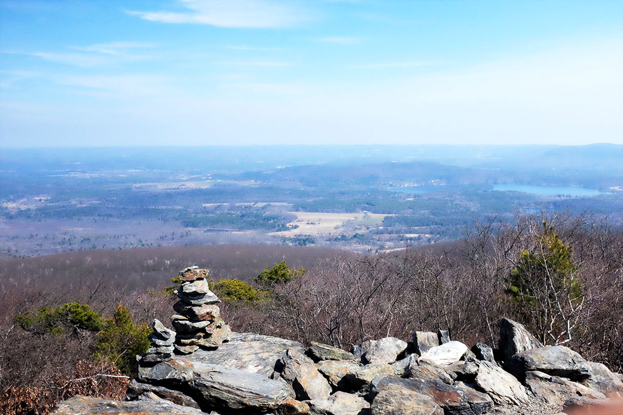
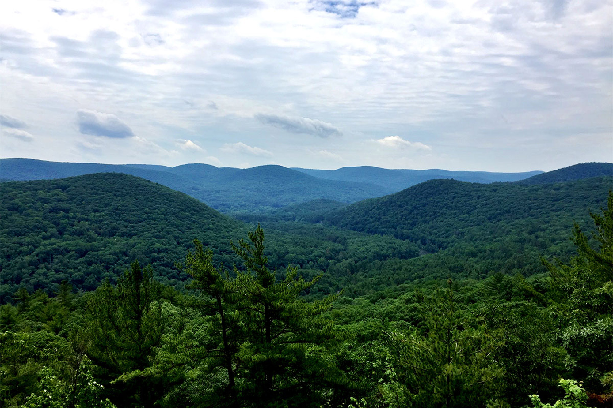
The Litchfield Hills in Connecticut’s Northwest Corner account for much of the state’s elevation gain and include both its highest point (on the slopes of Mount Frissell, whose summit is actually in Massachusetts) and its highest peak: Bear Mountain.
This six-mile loop starts out at the Undermountain Trailhead on CT-41 in Salisbury. The blue-blazed trail climbs steadily through a mixed forest before dead-ending at the Appalachian Trail. Bang a right (north) and keep climbing, a bit steeper now, over some semi-exposed ledges, until you reach the manmade stone pyramid at the summit, which is over 1,600 feet higher than where you started.
Once you’re on top, it’s easy to see why this is one of the state’s more popular hikes, despite its relatively remote location.
Descend by continuing north, down a steep stretch of boulders that turn into a bit of an icefall in winter. Keep on the AT to Sages Ravine just over the state line in Massachusetts. Head right yet again on the Paradise Lane Trail for a very chill, flat mile-and-a-half before you take a left back down the Undermountain Trail to the road.
Bonus: Make this a shuttle hike to take in Lion’s Head, an exposed ridge with more excellent views. Start your hike where the AT intersects with CT-41, just three miles south of the Undermountain Trailhead.
2. Macedonia Ridge Trail
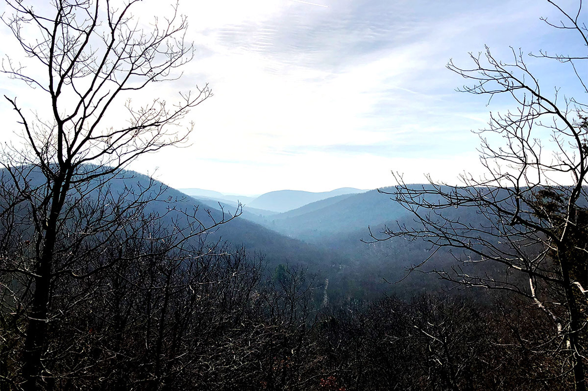
Another Litchfield Hills beauty is the Macedonia Ridge Trail in Kent. Running a 6.5-mile loop around Macedonia Brook State Park, the trail goes through four distinct ecosystems with a little bit of elevation change (around 1,750 feet gained, all told) and varies in footing from a narrow footpath to an old forest road to a ledge scramble.
Beginning from the parking area on Macedonia Brook Road, walk back along the road the way you came (south) to find the trailhead, which is marked by a light blue blaze on the opposite side.
Keep on following those blazes. You’ll get plenty of up-and-down over rolling hills through new-growth forest, along a densely fern-covered brook bed, and an old road with old stone walls that seem less like a manmade intrusion than a component of the surroundings.
At around mile 4.0, you start really going up, reaching a ledge with outstanding southerly views. Hop on down into a little hollow before coming to a fun scramble up to the summit of Cobble Mountain, the hike’s high-point with extensive views west. If you’re rolling with your puppy friend, they may need a hand at this part.
From the top, stick to the light blue blazes, and descend through abundant mountain laurel and coniferous forest for two miles or so back to the parking area.
Bonus: Kent Falls Brewing Company, an independent brewery on a working farm, is just a short drive from Macedonia Brook State Park. Grab yourself a beer—you deserve it.
3. Bigelow Hollow
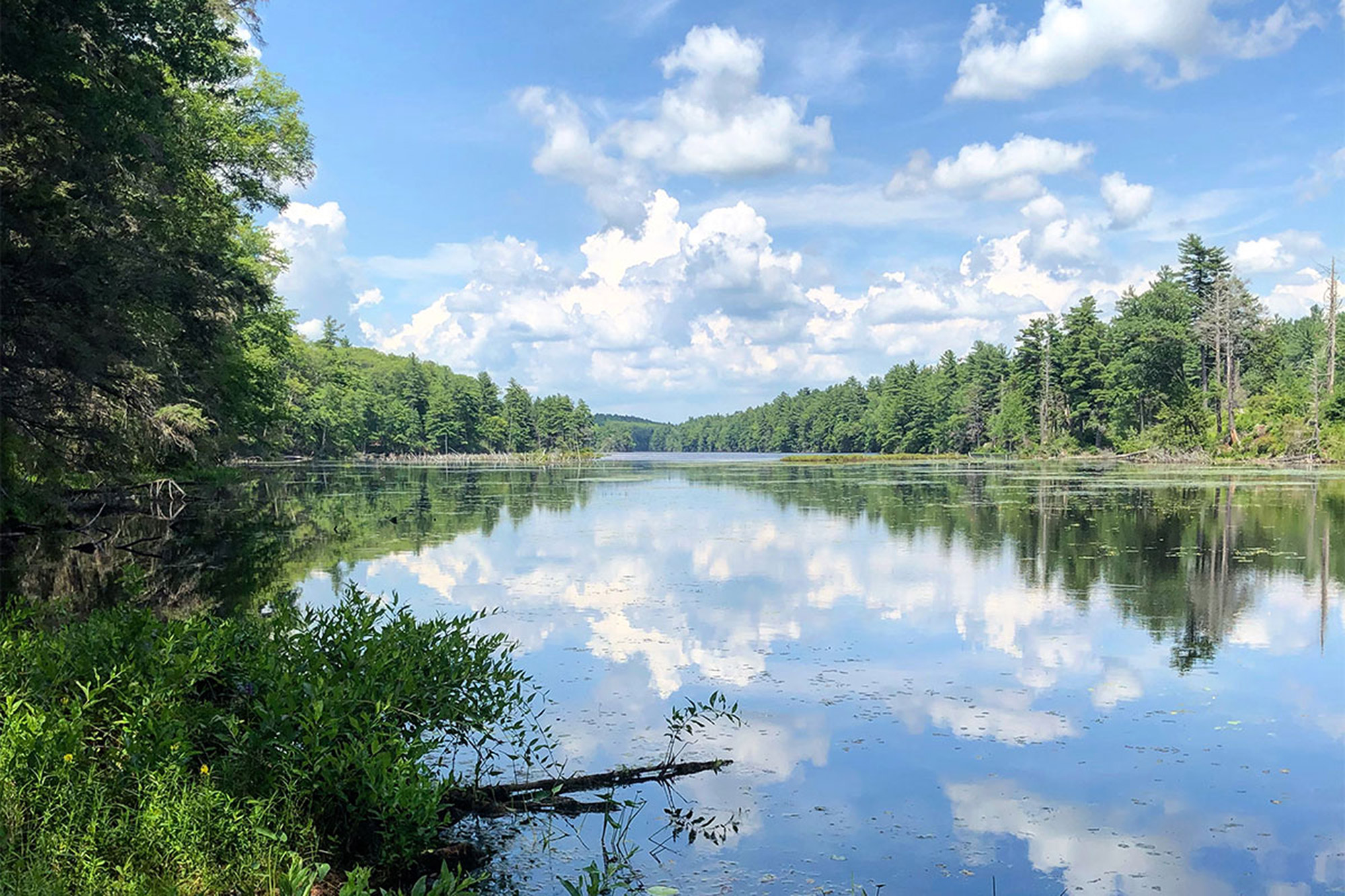
Connecticut’s “Quiet Corner,” the rural northeastern part of the state, is home to Bigelow Hollow State Park and Nipmuck State Forest. It’s just a hop, skip, and a jump from I-84 but far from everywhere else, and it feels that way.
Enter the state park on CT-171 in Union, and you’ll find the parking area about a half-mile up the access road on the left-hand side. Here, you can access a white-blazed trail that, after a quarter-mile, runs into the also-white-blazed Park Road, a forest road that runs from CT-171 to Breakneck Pond, our main destination.
Park Road is wide and generally flat—easy for hiking but watch out for the bug population in summer. After another 0.8 wooded miles, you’ll come to a junction with the East Ridge Trail and the Breakneck Pond View Trail, indicated by light blue and red blazes.
Take a left to follow this decidedly more rugged trail for another 1.8 miles. It quickly becomes a narrow footpath along the pond’s western shore and offers intermittent (and beautiful) lake views, until you enter Massachusetts for a quarter mile or so. Then, welcome back to Connecticut!
From here, the Breakneck Pond View Trail runs into the Nipmuck Trail. This takes you back down the pond’s eastern edge and features more intermittent-but-stunning views. Eventually, you’ll return to the junction with Park Road and get back to the parking area.
Bonus: You can do a circuit of the park’s three bodies of water—Bigelow Hollow Pond, Mashapaug Lake, and Breakneck Pond—with a cool, clover loop-style traverse. Total mileage: 11.8 mi.; total elevation: around 1,025 feet.
4. Devil’s Hopyard
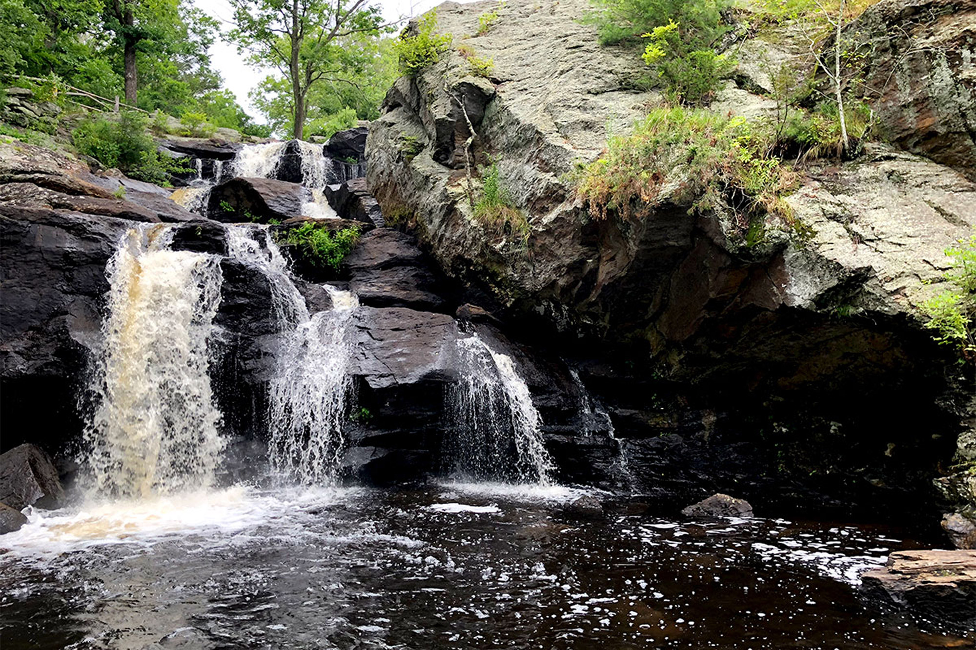
Devil’s Hopyard State Park in East Haddam is a cool spot with a cool name. It also packs a waterfall, a viewpoint, and a couple of geologic formations attributed to the devil into just 860 acres. Connecting the orange-blazed Vista Trail with the unnamed white-blazed trail makes a three-mile loop on the eastern side of the Eightmile River and hits all the highlights.
The area around the parking lot on Foxtown Road and the adjacent Chapman Falls is rather developed and may be mobbed on a nice day but don’t be discouraged. The falls are beautiful, and the woods are right around the corner.
Head down the path (with the falls at your left) and cross the covered bridge to access the Vista Trail. Head straight (south) to start your counterclockwise loop.
Follow the orange blazes, bearing right when the trail splits into two separate spur trails that are both worth checking out. The first, at 0.4 miles, is a short but very steep spur trail to the Devil’s Oven, a small cave in a massive rock formation located in a densely shaded hemlock grove. The second, at 0.8 miles, is the viewpoint that gives the Vista Trail its name. While it’s worth a stop for a snack and a drink, the rolling green hills and the lack of manmade structures make for a welcome relief in one of the country’s most densely populated states.
Back on the trail, at 1.4 miles, bang a right, leaving the Vista Trail for the White Trail. This trail winds its way for another 1.5 miles or so through dense forest back to the falls. However, take care when following the trail here. There are more than a few unblazed footpaths that crisscross this part of the woods.
Back at the falls, end your hike by checking out the potholes, a handful of unnaturally perfect, cylindrical pools carved into the ledge on the eastern bank. Credited to the devil by the area’s earliest settlers, these geologic anomalies were actually caused by tiny grains of sand caught up in the swirling eddies. Not a bad guess, though, by the settlers, since they wound up giving the park such an awesome-sounding name.
5. Pine Knob
Back in the Northwest Corner is the Pine Knob Loop, a short but sweet little hike in Housatonic Meadows State Park that connects the Appalachian Trail with US-7 in Sharon, CT. In just 2.5 miles, this route climbs around 750 feet in elevation and features some of Connecticut’s finest hiking.
From the trailhead parking lot, follow the blue-blazed Pine Knob Loop Trail into the woods, crossing Hatch Brook and running along an old stone wall up to a junction. Here, the Pine Knob Loop Trail splits, so continue to the left and begin climbing moderately.
With Hatch Brook to your left, the trail continues climbing through a pine forest. With a little breeze, the sounds of the wind through the pines and the brook running down the side of the hill make for a really special, peaceful time.
Keep on climbing, until this branch of the Pine Knob Loop Trail intersects with the white-blazed Appalachian Trail, and take a right. Here, the hike begins a relatively rough ascent, climbing over rocks to one of two excellent viewpoints.
Keep on the AT as it rolls over the ridge and ultimately begins descending. Then, rejoin the Pine Knob Loop Trail as it breaks off to the right. The trail descends steeply to another excellent viewpoint, before ultimately leveling out and arriving back at the split. Here, take a left, cross the brook again, and you’ll be back at the parking lot.
Related Posts


