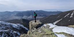
For the better part of four years, I have lived in Vermont. While being an undergrad doesn’t make me a true Vermonter, getting out and experiencing all there is to offer sure does. Since coming up here, I’ve gone on many hikes, and while you can’t go wrong with any trail, those looking to get the full experience should set their sights on the state’s high point, Mount Mansfield.
Butler Lodge Trail> Wallace Cut-off> Long Trail North> Mt. Mansfield Summit> Subway> Canyon North Extension> Canyon North> Canyon> Long trail South> Wampahoofus> Butler Lodge Trail: Approximately 8.2 miles
For three out of four seasons, I’ve summited Mt. Mansfield. What’s my tip for getting there? First, tune your GPS to the town of Underhill. Then, as you’re passing through on Route 15, look for River Road and finally Stevensville Road. Make sure you drive all the way to the end, where you’ll find a few spaces to park.
Now as you’re ready to hit the trail, gather up your gear and lace up your boots. The start first takes you along the road, where you’ll go over a bridge and then push left into the woods to a register. Here, I start with the Butler Lodge Trail, where your hike gradually increases through steady to steeper terrain. At this point, you’ll note a neat set of steps that was originally installed by the Civilian Conservation Corps during the Great Depression, and will soon arrive at Butler Lodge (1.8 mi) – probably my favorite spot in the state of Vermont.
![[Photo: Aaron Anderstrom]](https://goeast.ems.com/wp-content/uploads/2016/05/image00-300x300.jpg)
![[Photo: Aaron Anderstrom]](https://goeast.ems.com/wp-content/uploads/2016/05/image02-300x300.jpg)
![[Photo: Aaron Anderstrom]](https://goeast.ems.com/wp-content/uploads/2016/05/image01-300x300.jpg)
The cabin has aged beautifully, and once you’re inside, you’ll see the nice view from the balcony of the escarpment. After soaking in the scenery here, you will want to continue on your hike via the Wallace Cut-Off trail. This 0.1-mile stretch will bring you around the southwest ridge, where it then meets up with the Long Trail.
To experience the best section of the hike, jump on the LT and head up north to Mt. Mansfield’s forehead. Be alert, though: You will have to climb up some ladders, walk across some beams, and shimmy past some rocks before you come out on the bald forehead. Luckily, getting up to the summit, or “chin,” is an easier, more straightforward journey.
Here, the trail is comparatively flat, and as you continue on, you will round the nose to find the visitors center and parking area. A bit farther, you will pass through some small scrub pines before heading along the western side of the ridge up to the summit proper.
On a good day, you can see many layers of the Adirondacks to the west and get a clear view of the White Mountains in the east. In the right season, this can be an awesome spot to enjoy lunch and meet and greet everyone coming up the various trails to the top.
“On a good day, you can see many layers of the Adirondacks to the west and get a clear view of the White Mountains in the east.”
![[Photo: Aaron Anderstrom]](https://goeast.ems.com/wp-content/uploads/2016/05/image03-1024x278.jpg)
When you’re ready to head back down, go south the way you came but look for a sign that says “Subway.” This will bring you down a series of trails I collectively refer to as “The Canyon Set.” After enjoying the breathtaking sights of the Subway (0.3 mi.), you should follow Canyon North Extension (0.6 mi.), Canyon North (0.6 mi.), and Canyon (0.6 mi.) southward. This series parallels the summit ridge on the western slope, with numerous caves, canyons, tunnels, overhangs, and rock piles. As this is a very tricky section, take your time and enjoy it, especially as you have a view of Lake Champlain. If you are planning on taking these trails, use a smaller pack, so you can fit through all of the nooks and crannies along the way.
These trails pop you right back out on the CCC road. There, you will want to head back up towards the visitors center before rejoining the Long Trail heading south. From here, make your way back over to the Forehead, and for this portion, I typically take the Wampahoofus Trail (0.8 mi.) down to Butler Lodge. This trail supplies excellent views for a little while longer and involves some steep components, but all in all, it is a bit easier and offers a nice change of scenery. Once you arrive at Butler Lodge, all you have left is the Butler Lodge Trail back to the parking lot (1.8 mi.).
This trip is one of a kind and truly does capture some of the best mountain hiking Vermont has to offer. Keep in mind, as it’s a full-day venture, it’s important to gauge your fitness and the level of those you hike with.
Related Posts
April 12, 2024
Explore Like a Local: The Outdoor Mecca of North Conway, NH
There's a lot to love about this New…
April 3, 2024
5 Things To Do in the Boston Area During Mud Season
Adventure opportunities are abundant…


