

With fall foliage that rivals New England, a unique topography reminiscent of the Alaskan and Canadian tundra, and a bevy of wilderness areas flush with epic views but lacking crowds and complex permit systems, the Potomac Highlands of West Virginia possess some of the finest fall backpacking trips in America. From a quick and easy overnight to a multi-day odyssey far from official trails, it features some of the best backpacking you could find anywhere, for backpackers of all ability levels. Put these trips at the top of your backpacking to-do list this fall.
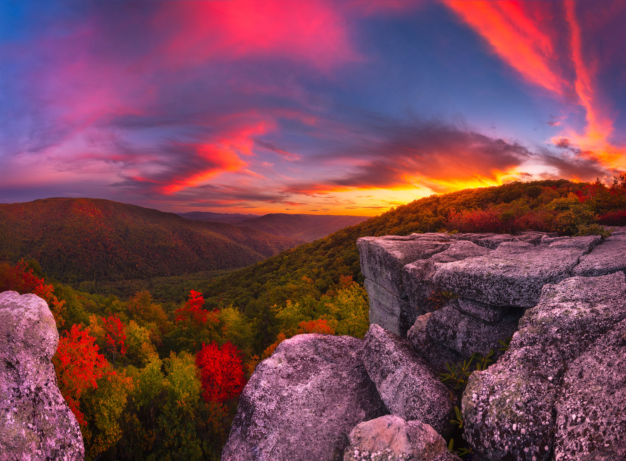
Table Rock
For an easy introduction to what fall backpacking in the Potomac Highlands is all about, head to the Canaan Mountain Backcountry Area and tackle the 2.4-mile roundtrip trek to Table Rock. With a short distance, minimal elevation gain, and astonishing views, Table Rock might be the best bang-for-your-buck hike in the entire state. Even better, this trail receives surprisingly light hiking pressure since the majority of backpackers head to the nearby Dolly Sods Wilderness.
From the small trailhead parking lot on Canaan Loop Road, take the Table Rock Trail through a pretty forest of hardwoods that will be bursting with color in late September and early October. After 1.2 mostly flat miles, break out of the forest onto appropriately named Table Rock, and behold a 180-degree view of mountains and the Cheat River Valley. Be mindful of crevasses in the rock as you explore, and then set up camp at a protected campsite back in the woods that was passed just before reaching the overlook. Or, if the weather is clear and calm, consider sleeping under the stars out on Table Rock. Wherever you decide to camp, be sure to pack in all the water you’ll need, as there isn’t a water source on this trip. Rise early the next morning to have your coffee while watching the sunrise illuminate the fog-filled valley and colorful autumn foliage before making the return trip to the car.
Dolly Sods Wilderness
Dolly Sods Wilderness is one of the most popular and well-known wilderness areas in West Virginia, and for good reason. With a vast network of trails, a bounty of campsites and several overlooks that provide panoramic views of nothing but seemingly endless wilderness, there are countless routes in Dolly Sods that are perfect for a fall backpacking trip. Since Dolly Sods is a designated Wilderness, be prepared for minimal or no trail markings and to ford creek crossings, all of which helps to preserve a true wilderness feel as much as possible.
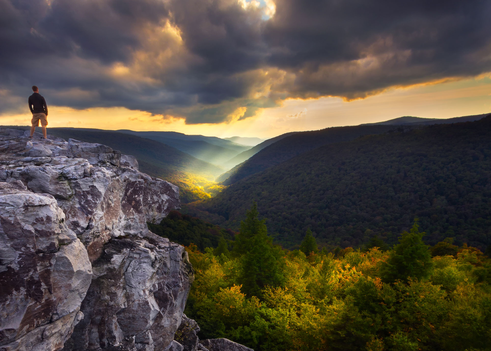
For a 19.4-mile (3 nights is best) lollipop loop that showcases the best of Dolly Sods, take the Rohrbaugh Plains Trail north from the Dolly Sods Picnic Area on Forest Service Road 19. In 2.5 miles, the first great views of the trip can be had from a rocky outcrop just off the trail. This overlook on the edge of Red Creek Canyon provides some of the best views in Dolly Sods, with Red Creek Valley below framed by Breathed Mountain and Rohrbaugh Plains. While only 2.5 miles from the trailhead, the view from here is so astounding that it’s worth spending a night at one of the campsites dispersed in the woods near the overlook. Sunsets from here are incredible, and on cool fall mornings fog often fills the valley below, making for truly dreamy photo conditions.
After breaking camp, continue on the Rohrbaugh Plains Trail and pass the Wildlife Trail on the right at 3.1 miles. Continue straight and drop down into Red Creek Canyon and cross Fisher Spring Run at 3.4 miles. Follow Fisher Spring Run Trail down to Red Creek, and pick up the Red Creek Trail to begin a 10-mile counterclockwise loop. Reach Rocky Point Trail on the left at 4.4 miles, which makes for a great side trip (add roughly 2 miles roundtrip) up to Lions Head, a rocky overlook that provides one of the best views in Dolly Sods, and possible campsites nearby. Continuing north from the junction with the Rocky Point Trail on the Red Creek Trail, reach the Breathed Mountain Trail at 6.0 miles. This trip takes you left down the Breathed Mountain Trail, but one could also continue straight down the Red Creek Trail to arrive at a fantastic and popular camping area near some waterfalls on Red Creek called “The Forks.”
Back at the junction with the Breathed Mountain Trail, take this trail west for 2.4 miles and travel through a beautiful forest of spruce and blueberry bogs. This combination of forest flora is more commonly found in the boreal forests of Canada than the Appalachian Mountains, and is especially beautiful in autumn when the berry bushes turn bright red and are a perfect contrast to the dark green spruce forests. Arrive at the Big Stonecoal Trail at 8.5 miles and turn left to head south down this trail for 2.4 miles before arriving at a trail junction with the Dunkenbarger Trail. Excellent campsites along Big Stonecoal Run can be found here.
Continuing south on Big Stonecoal Trail, the western end of the Rocky Point Trail to Lions Head is passed on the left at 11.6 miles, and in 1.4 more miles ford Red Creek and arrive back at Red Creek Trail at 13.0 miles. The banks of Red Creek possess several wonderful campsites, and Red Creek (named for the reddish-brown tint of the water caused by a high tannins concentration from decomposing red spruce and hemlock needles) is perfect for cooling tired feet after a long day on the trail. Continue heading northeast along the Red Creek Trail for 1.5 miles before hitting the intersection with Fisher Spring Run Trail, at which point you’ll be retracing your steps from the start of the trip back to the parking lot.
North Fork Mountain
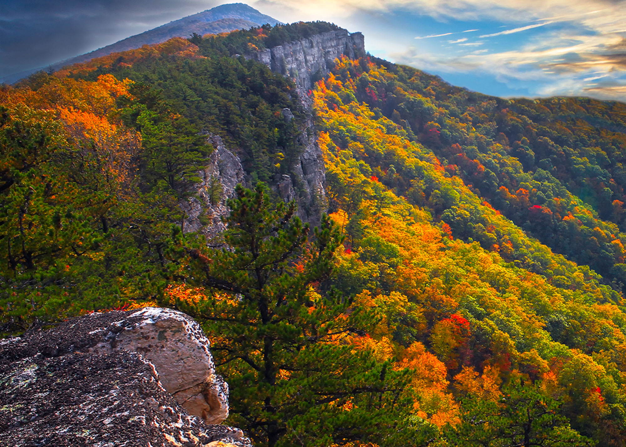
For fans of ridge hikes with near constant views, it doesn’t get any better than an autumn trek along North Fork Mountain. The full length of the ridge hike is 24.7 miles in total from end to end and makes a great shuttle hike if a car can be dropped at both trailheads (it’s about a 40-minute drive one-way between the north and south trailheads). It’s also possible to break this up into smaller shuttle sections, especially if starting from the northern trailhead. From the northern trailhead on CR 28 (Smoke Hole Rd.), ascend switchbacks for 1.6 miles to gain the ridge. Once up on the ridge, views and campsites abound, and there is minimal elevation change. Hike south and take a short side trail on the right that leads to Chimney Top, which provides a spectacular view of distant mountains and autumn foliage peppering the pastoral countryside far below. Countless other vistas await further down the trail, as the ridge never strays far from a clear view.
Three quarters of a mile further south, pass another fine vista, Table Rock (not the same Table Rock as the one previously discussed at the start of this article). If short on time or energy, this makes for a great stopping point, and several nice campsites can be found dispersed in the forest not far from the trail that provide easy access to sunset views from the ridge. From Table Rock, the trail ambles south and passes two spur trails that descend east off the ridge: Landis Trail and Redman Run Trail, reached 4.1 and 8.2 miles from the north trailhead, respectively. Taking either of these trails would provide a shorter shuttle hike alternative.
The main disadvantage of being up on the ridge is the scarcity of water. Save for a semi-reliable spring that’s passed halfway through the trail, there’s no water sources up on the ridge, so it’s best to pack in enough water to last the length of the trip in case the spring is dry.
The views continue on the southern portion of the trail, with so many overlooks that they don’t even have names. While the north half of the trail is more interesting, the southern half to the southern trailhead is still beautiful, and completing the full length of the trail is a rewarding and recommended experience.
Roaring Plains
For the seasoned backpacker looking for a trip that’s as challenging as it is scenic, there’s no better destination in the Potomac Highlands than a part off-trail wilderness sojourn in the Roaring Plains West Wilderness. Backpackers with the necessary skills are rewarded with some of the most incomparable solitude, views, and campsites to be found not only in West Virginia, but the entire East Coast. Given the largely off-trail nature of this route, it’s wise to budget extra time in case you get turned around, and to pack a map and compass and know how to use them. A GPS could also be incredibly useful for this trip.
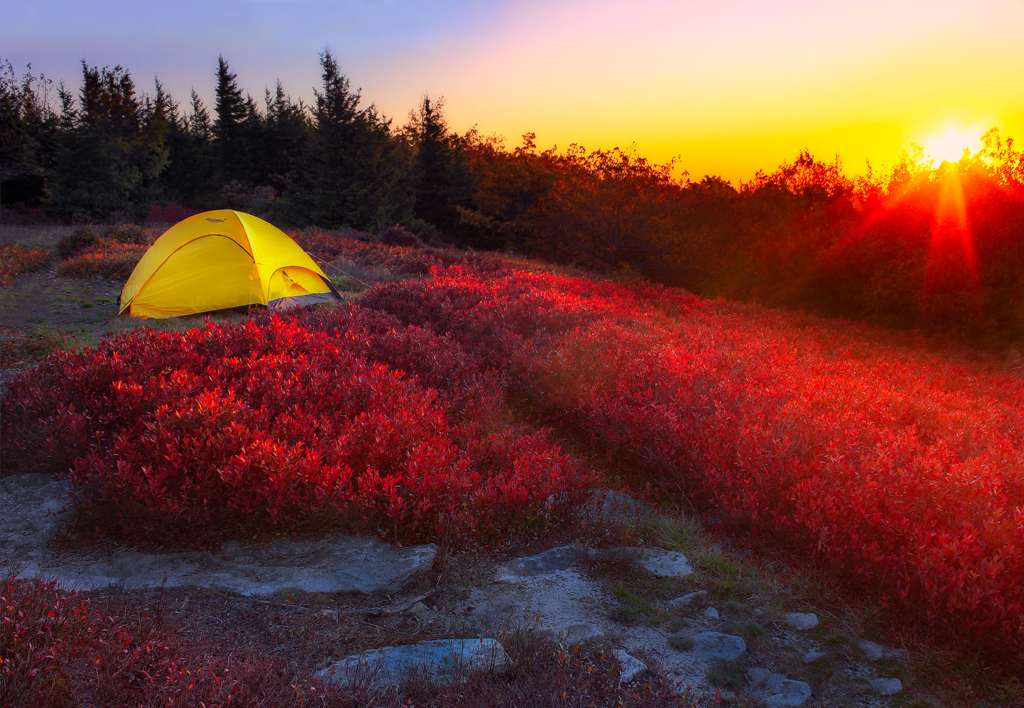
There are several possible routes that can be taken into the Roaring Plains, with the eastern fork of the South Prong Trail (which begins just a half mile down FS 19 from the start of the aforementioned Dolly Sods Wilderness trip) offering a pleasant, relatively flat portal to the rugged terrain that lies ahead. After heading south for approximately 2.5 miles on the oftentimes wet and muddy South Prong Trail, the real fun begins. Look for an unofficial trail on the left, not marked with a trail sign but often marked with a cairn, which heads in a southwest direction through the forest. Take it slow, keeping an eye on your compass and be on the lookout for more cairns marking the way along the faint trail, known as the “Hidden Passage.” After almost a mile of picking your way through the forest, break out into an open meadow with expansive views. Soon after arriving at the meadow, the trail passes one of the finest campsites imaginable, nestled in the flame-red berry bushes and with the kind of expansive, open views that are hard to come by when backcountry camping in the East. This area makes a great basecamp option to do day hikes from, with the top hiking option being an off-trail journey along the rim of Long Run Canyon.
To get Long Run Canyon from the meadows campsite, follow a faint, unmarked trail for about 0.7 miles through the open meadows, until reaching the Pipeline Swath (essentially an old dirt road). A small trickling creek located at this junction is one of the only water sources if camping at the meadows and for the duration of the loop along Long Run Canyon, so top off water bottles here and be sure to treat the water. Take a left to head southeast on the Pipeline for about 0.3 miles until arriving at the remains of an old road, where the real adventure begins.
Turning right, dive into the bush and head in a west-northwest direction to reach the rim of Long Run Canyon. Scan for a faint path possibly marked with cairns or flagging, and budget extra time for this section of the hike, as it’s the sketchiest part from a navigation standpoint. Once you arrive at the canyon rim, the trail is much easier to follow. When in doubt, ensure that the canyon is on your left. The next 2.5 miles are some of finest hiking miles imaginable, with almost constant views out across the canyon into the vast West Virginia wilderness. Heath thickets, spruce, and rocky outcroppings combine to form an incredibly beautiful and unique landscape unlike anything else in the East. While there is minimal elevation change on this section of the hike, since this is an unmaintained trail, there will almost certainly be downed trees to navigate around.
While base-camping at the meadows will make the hike along the canyon rim easier, for the hardy backpacker there are several options for camping along the canyon rim. Although water is hard to come by along the canyon, the views and solitude more than make up for the extra effort of hauling in water. Some of the best campsites are just past possibly the finest view of the day, at a spot called “The Point,” reached 1.5 miles into the hike along the canyon rim. From The Point, head northwest and in one mile arrive at a large campsite with a fire ring. On the north side of the campsite, look for a cairn and the start of your journey away from the canyon rim on the Tee-Pee “trail.” Another unofficial trail that can be a pain to follow, it’s best to set a northeast compass bearing and do your best to follow the faint boot path while sticking to the compass bearing. A half-mile bushwhack will lead to the Roaring Plains Trail, which is an official Forest Service trail. Turn right (east) onto the Roaring Plains trail, and in 0.9 miles again reach the Pipeline Swath. Turn right onto the Pipeline, and head southwest for one mile before arriving back at the base of the meadows, where you’ll turn left and retrace your steps from earlier in the day to return to basecamp in the meadows, having completed one of the most rugged and beautiful fall hikes imaginable.
Related Posts


